
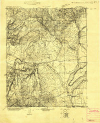
~ Abiquiu NM topo map, 1:125000 scale, 30 X 30 Minute, Historical, 1918
Abiquiu, New Mexico, USGS topographic map dated 1918.
Includes geographic coordinates (latitude and longitude). This topographic map is suitable for hiking, camping, and exploring, or framing it as a wall map.
Printed on-demand using high resolution imagery, on heavy weight and acid free paper, or alternatively on a variety of synthetic materials.
Topos available on paper, Waterproof, Poly, or Tyvek. Usually shipping rolled, unless combined with other folded maps in one order.
- Product Number: USGS-5386200
- Free digital map download (high-resolution, GeoPDF): Abiquiu, New Mexico (file size: 9 MB)
- Map Size: please refer to the dimensions of the GeoPDF map above
- Weight (paper map): ca. 55 grams
- Map Type: POD USGS Topographic Map
- Map Series: HTMC
- Map Verison: Historical
- Cell ID: 64846
- Scan ID: 189268
- Datum: Unstated
- Map Projection: Polyconic
- Advance: Yes
- Map published by United States Geological Survey
- Keywords: Nonstandard Press Run
- Map Language: English
- Scanner Resolution: 600 dpi
- Map Cell Name: Abuquiu
- Grid size: 30 X 30 Minute
- Date on map: 1918
- Map Scale: 1:125000
- Geographical region: New Mexico, United States
Neighboring Maps:
All neighboring USGS topo maps are available for sale online at a variety of scales.
Spatial coverage:
Topo map Abiquiu, New Mexico, covers the geographical area associated the following places:
- La Cueva (historical) - Las Placitas - La Careda - El Duende - Clara Peak - Vallecitos - Gallegos - Barranca - San Lorenzo - Chili - El Rito - Alcalde - Lower Cañones - Canjilon - La Villita - Guique - Fairview - San Jose - Tierra Azul - Estaca - Plaza Blanca - Vallecitos Corrales - Pueblito - Ojo Caliente - Cañones - La Madera - Ancones - South Petaca - San Juan Pueblo - Medanales - Placitas - Recheulos - El Monte Rojo - Frijoles Spring - Buena Vista - Los Luceros - Duranes - Ranchitos - El Guacho - Abiquiu - Hernandez - Vallecitos - Chamita - La Chuachia - Santo Niño - El Curuco - La Madera - Lyden - El Llano
- Map Area ID: AREA36.536-106.5-106
- Northwest corner Lat/Long code: USGSNW36.5-106.5
- Northeast corner Lat/Long code: USGSNE36.5-106
- Southwest corner Lat/Long code: USGSSW36-106.5
- Southeast corner Lat/Long code: USGSSE36-106
- Northern map edge Latitude: 36.5
- Southern map edge Latitude: 36
- Western map edge Longitude: -106.5
- Eastern map edge Longitude: -106


