
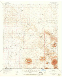
~ Alamo Mountain NM topo map, 1:62500 scale, 15 X 15 Minute, Historical, 1959, updated 1960
Alamo Mountain, New Mexico, USGS topographic map dated 1959.
Includes geographic coordinates (latitude and longitude). This topographic map is suitable for hiking, camping, and exploring, or framing it as a wall map.
Printed on-demand using high resolution imagery, on heavy weight and acid free paper, or alternatively on a variety of synthetic materials.
Topos available on paper, Waterproof, Poly, or Tyvek. Usually shipping rolled, unless combined with other folded maps in one order.
- Product Number: USGS-5385258
- Free digital map download (high-resolution, GeoPDF): Alamo Mountain, New Mexico (file size: 7 MB)
- Map Size: please refer to the dimensions of the GeoPDF map above
- Weight (paper map): ca. 55 grams
- Map Type: POD USGS Topographic Map
- Map Series: HTMC
- Map Verison: Historical
- Cell ID: 50385
- Scan ID: 189511
- Imprint Year: 1960
- Aerial Photo Year: 1958
- Field Check Year: 1959
- Datum: NAD27
- Map Projection: Polyconic
- Map published by United States Geological Survey
- Map Language: English
- Scanner Resolution: 600 dpi
- Map Cell Name: Alamo Mountain
- Grid size: 15 X 15 Minute
- Date on map: 1959
- Map Scale: 1:62500
- Geographical region: New Mexico, United States
Neighboring Maps:
All neighboring USGS topo maps are available for sale online at a variety of scales.
Spatial coverage:
Topo map Alamo Mountain, New Mexico, covers the geographical area associated the following places:
- Jug Tank - Lake Tank - J T Tank - New Tank Draw - Cactus Tank - Hat Ranch - Chess Tank - Alamo Springs Stage Station Historic Site - Rob Tanks - Mixen Tank - Pate Windmill - Center Windmill - Zazu Tank - The Lake - State Line Tank - Badger Well - Wimberly Ranch - Cornudas Mountain Prospect - Wind Mountain Well - Deer Mountain - Hood Tank - Flat Top - Lee Detention Dam - Alamo Mountain - Partnership Well - Murphy Tank - Rim Tank - Vince Tank - Wiley Bar Ranch (historical) - Grief Well - Alamo Spring - Cornudas Ranch - Cornudas Mountain - Cowan Lake - CCC Tank - Cornudas Tank - Hackberry Draw - Alamo Tank - Bennett Ranch - Lake Tank - Green Tank - Grief Tank - Line Tank - Big Tank - Alamo Windmill - Hackberry Tank - Chess Well - Cornudas Mountains - CCC Tank - Brownfield Tank - Potter Tank - Wind Mountain - Copper Bottom Tank - Two- High Tanks - Long Tank - New Tank - Perry Windmill - King Tank - Tulloch Lake - B T Ranch - Harris Tank
- Map Area ID: AREA32.2532-105.75-105.5
- Northwest corner Lat/Long code: USGSNW32.25-105.75
- Northeast corner Lat/Long code: USGSNE32.25-105.5
- Southwest corner Lat/Long code: USGSSW32-105.75
- Southeast corner Lat/Long code: USGSSE32-105.5
- Northern map edge Latitude: 32.25
- Southern map edge Latitude: 32
- Western map edge Longitude: -105.75
- Eastern map edge Longitude: -105.5


