
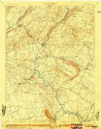
~ High Bridge NJ topo map, 1:62500 scale, 15 X 15 Minute, Historical, 1905
High Bridge, New Jersey, USGS topographic map dated 1905.
Includes geographic coordinates (latitude and longitude). This topographic map is suitable for hiking, camping, and exploring, or framing it as a wall map.
Printed on-demand using high resolution imagery, on heavy weight and acid free paper, or alternatively on a variety of synthetic materials.
Topos available on paper, Waterproof, Poly, or Tyvek. Usually shipping rolled, unless combined with other folded maps in one order.
- Product Number: USGS-8526974
- Free digital map download (high-resolution, GeoPDF): High Bridge, New Jersey (file size: 8 MB)
- Map Size: please refer to the dimensions of the GeoPDF map above
- Weight (paper map): ca. 55 grams
- Map Type: POD USGS Topographic Map
- Map Series: HTMC
- Map Verison: Historical
- Cell ID: 55322
- Scan ID: 255225
- Edit Year: 1903
- Survey Year: 1886
- Datum: Unstated
- Map Projection: Unstated
- Map published by United States Geological Survey
- Map Language: English
- Scanner Resolution: 600 dpi
- Map Cell Name: High Bridge
- Grid size: 15 X 15 Minute
- Date on map: 1905
- Map Scale: 1:62500
- Geographical region: New Jersey, United States
Neighboring Maps:
All neighboring USGS topo maps are available for sale online at a variety of scales.
Spatial coverage:
Topo map High Bridge, New Jersey, covers the geographical area associated the following places:
- Fairmount - Lansdowne - Red Mill - Annandale - Glen Gardner - Flemington - High Bridge - Voorhees Corner - Pittstown - Whitehouse Station - Spruce Run - Allerton - Anthony - Grandin - Hampton Junction - Cherryville - Lebanon - Mount Salem - Higginsville - Cushetunk - Cokesbury - Newport - Darts Mills - Clarksville - Thachers Hill - Fairmount - Stanton - Norton - Laurel Farms - Littletown - Perryville - Lower Valley - Changewater - Rowland Mills - Hensfoot - Gary Corner - Woodfern - Charlestown - Califon - Bunnvale - Vernoy - Stone Mill - Crestmoore - Polktown - Sunnyside - Clinton - Readingsburg - Flemington Junction - Woodglen - Farmersville - Mariannes Corner - McPherson - Franklin - Pleasant Run - Dreahook - Klinesville - Riverside - Jutland - New Hampton - Mountainville - Bartles Corners - Lower Fairmount - Sidney - Hamden - Point Breeze - Rockefellows Mills - Potterstown - Allens Corner - Kingtown - Alvater Corner - Three Bridges - McCrea Mills - Centerville - Van Syckel - Union - Bells Crossing - Mechlings Corner - Cedar Heights - Quakertown - Holcomb Mills - Hoffmans - Hampton - Oak Grove - Pierce Heights - Bissell - Croton - Little Brook
- Map Area ID: AREA40.7540.5-75-74.75
- Northwest corner Lat/Long code: USGSNW40.75-75
- Northeast corner Lat/Long code: USGSNE40.75-74.75
- Southwest corner Lat/Long code: USGSSW40.5-75
- Southeast corner Lat/Long code: USGSSE40.5-74.75
- Northern map edge Latitude: 40.75
- Southern map edge Latitude: 40.5
- Western map edge Longitude: -75
- Eastern map edge Longitude: -74.75


