
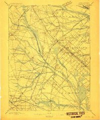
~ Hammonton NJ topo map, 1:62500 scale, 15 X 15 Minute, Historical, 1898, updated 1912
Hammonton, New Jersey, USGS topographic map dated 1898.
Includes geographic coordinates (latitude and longitude). This topographic map is suitable for hiking, camping, and exploring, or framing it as a wall map.
Printed on-demand using high resolution imagery, on heavy weight and acid free paper, or alternatively on a variety of synthetic materials.
Topos available on paper, Waterproof, Poly, or Tyvek. Usually shipping rolled, unless combined with other folded maps in one order.
- Product Number: USGS-8526966
- Free digital map download (high-resolution, GeoPDF): Hammonton, New Jersey (file size: 7 MB)
- Map Size: please refer to the dimensions of the GeoPDF map above
- Weight (paper map): ca. 55 grams
- Map Type: POD USGS Topographic Map
- Map Series: HTMC
- Map Verison: Historical
- Cell ID: 55031
- Scan ID: 255217
- Imprint Year: 1912
- Survey Year: 1886
- Datum: Unstated
- Map Projection: Unstated
- Map published by United States Geological Survey
- Map Language: English
- Scanner Resolution: 600 dpi
- Map Cell Name: Hammonton
- Grid size: 15 X 15 Minute
- Date on map: 1898
- Map Scale: 1:62500
- Geographical region: New Jersey, United States
Neighboring Maps:
All neighboring USGS topo maps are available for sale online at a variety of scales.
Spatial coverage:
Topo map Hammonton, New Jersey, covers the geographical area associated the following places:
- Berryland - Newtonville - Blue Anchor - Piney Hollow - Folsom - Penny Pot - Blue Bell - Rosedale - Cecil - Murphy - Cedar Brook - Forest Grove - West Atco - Elm - Broad Lane - Brimfield Crossing - Bates Mill - Winslow Junction - Winslow - Williamstown - Collings Lakes - Downstown - Cedar Lake - Williamstown Junction - Pancoast - Weymouth - New Brooklyn - Parkdale - Buena - Andrews - Waterford Works - Sicklerville - Landisville - Da Costa - Barnard - Braddock - Chesilhurst - Wheat Road - Florence - Minotola - Victory Lakes - Hammonton - Dunbarton - Ancora - Pestletown
- Map Area ID: AREA39.7539.5-75-74.75
- Northwest corner Lat/Long code: USGSNW39.75-75
- Northeast corner Lat/Long code: USGSNE39.75-74.75
- Southwest corner Lat/Long code: USGSSW39.5-75
- Southeast corner Lat/Long code: USGSSE39.5-74.75
- Northern map edge Latitude: 39.75
- Southern map edge Latitude: 39.5
- Western map edge Longitude: -75
- Eastern map edge Longitude: -74.75


