
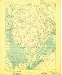
~ Great Egg Harbor NJ topo map, 1:62500 scale, 15 X 15 Minute, Historical, 1893
Great Egg Harbor, New Jersey, USGS topographic map dated 1893.
Includes geographic coordinates (latitude and longitude). This topographic map is suitable for hiking, camping, and exploring, or framing it as a wall map.
Printed on-demand using high resolution imagery, on heavy weight and acid free paper, or alternatively on a variety of synthetic materials.
Topos available on paper, Waterproof, Poly, or Tyvek. Usually shipping rolled, unless combined with other folded maps in one order.
- Product Number: USGS-8526930
- Free digital map download (high-resolution, GeoPDF): Great Egg Harbor, New Jersey (file size: 6 MB)
- Map Size: please refer to the dimensions of the GeoPDF map above
- Weight (paper map): ca. 55 grams
- Map Type: POD USGS Topographic Map
- Map Series: HTMC
- Map Verison: Historical
- Cell ID: 61078
- Scan ID: 255186
- Survey Year: 1886
- Datum: Unstated
- Map Projection: Unstated
- Map published by United States Geological Survey
- Map Language: English
- Scanner Resolution: 600 dpi
- Map Cell Name: Pleasantville
- Grid size: 15 X 15 Minute
- Date on map: 1893
- Map Scale: 1:62500
- Geographical region: New Jersey, United States
Neighboring Maps:
All neighboring USGS topo maps are available for sale online at a variety of scales.
Spatial coverage:
Topo map Great Egg Harbor, New Jersey, covers the geographical area associated the following places:
- English Creek Landing - Pomona - Scullville - Petersburg - Scull Landing - Estell Manor - Wilsons Landing - McKee City - Clarkstown - Bargaintown - Ocean City - High Bank Landing - Pleasantville - Clover Leaf Lakes - Belcoville - Ocean Heights - Beesleys Point - Thelma - Middletown - Longport - Reega - Mount Pleasant - Gibson Landing - Laureldale - Cardiff - Catawba - Morris Beach - Estellville - Northfield - Pinehurst - Marmora - Gravelly Run - Steelmanville - Steelman Landing - Margate City - Linwood - Mays Landing - Thompsontown - Jeffers Landing - Somers Point - English Creek
- Map Area ID: AREA39.539.25-74.75-74.5
- Northwest corner Lat/Long code: USGSNW39.5-74.75
- Northeast corner Lat/Long code: USGSNE39.5-74.5
- Southwest corner Lat/Long code: USGSSW39.25-74.75
- Southeast corner Lat/Long code: USGSSE39.25-74.5
- Northern map edge Latitude: 39.5
- Southern map edge Latitude: 39.25
- Western map edge Longitude: -74.75
- Eastern map edge Longitude: -74.5


