
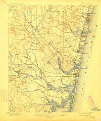
~ Asbury Park NJ topo map, 1:62500 scale, 15 X 15 Minute, Historical, 1901, updated 1912
Asbury Park, New Jersey, USGS topographic map dated 1901.
Includes geographic coordinates (latitude and longitude). This topographic map is suitable for hiking, camping, and exploring, or framing it as a wall map.
Printed on-demand using high resolution imagery, on heavy weight and acid free paper, or alternatively on a variety of synthetic materials.
Topos available on paper, Waterproof, Poly, or Tyvek. Usually shipping rolled, unless combined with other folded maps in one order.
- Product Number: USGS-5685947
- Free digital map download (high-resolution, GeoPDF): Asbury Park, New Jersey (file size: 9 MB)
- Map Size: please refer to the dimensions of the GeoPDF map above
- Weight (paper map): ca. 55 grams
- Map Type: POD USGS Topographic Map
- Map Series: HTMC
- Map Verison: Historical
- Cell ID: 50710
- Scan ID: 255088
- Imprint Year: 1912
- Survey Year: 1884
- Datum: Unstated
- Map Projection: Unstated
- Map published by United States Geological Survey
- Keywords: Overedge with No Adjacent Map
- Map Language: English
- Scanner Resolution: 600 dpi
- Map Cell Name: Asbury Park
- Grid size: 15 X 15 Minute
- Date on map: 1901
- Map Scale: 1:62500
- Geographical region: New Jersey, United States
Neighboring Maps:
All neighboring USGS topo maps are available for sale online at a variety of scales.
Spatial coverage:
Topo map Asbury Park, New Jersey, covers the geographical area associated the following places:
- Winston Park - Williams - Silverton Pine Terrace - Carmerville - Allaire - Bradley Park - Candlewood - Camp Osborne - Mantoloking Shores - Herbertsville - Leisure Village East - West Belmar - Remsen Mill - Winding River Village - Bricktown - Osbornsville - Pine Terrace - Ardmore Estates - Point Pleasant - Freewood Acres - Blansingburg - Evergreen Shores - Laurelton - Osbornes Mills - Chestnut Estates - West Allenhurst - Shore Acres - Sterling Woods - Deal - Loch Arbour - Land of Pines - Avon-by-the-Sea - Baileys Corner - Spring Lake Heights - Manasquan - West Osbornsville - Shacks Corner - Glendola - Belmar - Algers Mills - Whitesville - Adamston - West Mantoloking - Green Island - Asbury Park - Wanamassa - Pleasant Plains - Cedar Bridge Manor - Greenbriar - Shark River Hills - Lakewood Corner Estates - Larrabees - Brielle - Metedeconk - Parkway Pines - Coventry Square - Mandalay - Lake Como - Bay Head - Holiday City - Bay Harbor Estates - Manasquan Park - Lakewood - Allenhurst - Riviera on the Bay - Interlaken - Lanes Mills - Earle - Lower Squankum - Bradley Beach - Clarks Landing - Mantoloking Estates - Riviera Beach - Hamilton - Neptune City - Edgemere Estates - Ocean Grove - Silverton Estates - Jerseyville - White Oak Bottom - Greenville - Mantoloking - Seven Stars - Silverton - Oak Hill - West Deal - Sea Girt - Salem Hill - Cold Indian Springs - Glen Cedar City - Breton Woods - Fairfield - Spruce Gardens - Cedarwood Park - New Bedford - Baywood - Collingwood Park - Bay Head Junction - Cherry Quay - South Belmar
- Map Area ID: AREA40.2540-74.25-74
- Northwest corner Lat/Long code: USGSNW40.25-74.25
- Northeast corner Lat/Long code: USGSNE40.25-74
- Southwest corner Lat/Long code: USGSSW40-74.25
- Southeast corner Lat/Long code: USGSSE40-74
- Northern map edge Latitude: 40.25
- Southern map edge Latitude: 40
- Western map edge Longitude: -74.25
- Eastern map edge Longitude: -74


