
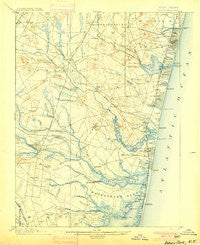
~ Asbury Park NJ topo map, 1:62500 scale, 15 X 15 Minute, Historical, 1901
Asbury Park, New Jersey, USGS topographic map dated 1901.
Includes geographic coordinates (latitude and longitude). This topographic map is suitable for hiking, camping, and exploring, or framing it as a wall map.
Printed on-demand using high resolution imagery, on heavy weight and acid free paper, or alternatively on a variety of synthetic materials.
Topos available on paper, Waterproof, Poly, or Tyvek. Usually shipping rolled, unless combined with other folded maps in one order.
- Product Number: USGS-5685941
- Free digital map download (high-resolution, GeoPDF): Asbury Park, New Jersey (file size: 8 MB)
- Map Size: please refer to the dimensions of the GeoPDF map above
- Weight (paper map): ca. 55 grams
- Map Type: POD USGS Topographic Map
- Map Series: HTMC
- Map Verison: Historical
- Cell ID: 50710
- Scan ID: 255085
- Survey Year: 1884
- Datum: Unstated
- Map Projection: Unstated
- Map published by United States Geological Survey
- Keywords: Overedge with No Adjacent Map
- Map Language: English
- Scanner Resolution: 600 dpi
- Map Cell Name: Asbury Park
- Grid size: 15 X 15 Minute
- Date on map: 1901
- Map Scale: 1:62500
- Geographical region: New Jersey, United States
Neighboring Maps:
All neighboring USGS topo maps are available for sale online at a variety of scales.
Spatial coverage:
Topo map Asbury Park, New Jersey, covers the geographical area associated the following places:
- West Farms - Loch Arbour - Evergreen Shores - Algers Mills - Winston Park - Squankum - Ocean Grove - Asbury Park - Silverton Pine Terrace - Lake Riviera - Seven Stars - Earle - Manasquan - White Oak Bottom - Clarks Landing - Holiday City - Shark River Hills - Deal - Riviera Beach - Lake Club - Spring Lake - Fairfield - Cedar Bridge - Whitesville - Sterling Woods - Cedar Bridge Manor - Herbertsville - Ramtown - Point Pleasant Beach - Cold Indian Springs - Carmerville - Riviera on the Bay - Lower Squankum - Leisure Village - Bradley Park - Ardena - Shore Acres - Cedarwood Park - Southard - Sea Girt - Jerseyville - Hamilton - Leisure Village East - Laurelton Gardens - Allenwood - Larrabees - Lakewood - Glendola - West Deal - Normandy Beach - Reevytown - Adamston - Freewood Acres - Metedeconk - Pine Terrace - West Mantoloking - Osbornsville - South Mantoloking Beach - Ardmore Estates - Oak Glen - Wanamassa - West Belmar - Shacks Corner - Oak Hill - Remsen Mill - Green Island - Greenville - Villa Park - Allaire - Neptune City - Bay Head Junction - Bradley Beach - West Point Pleasant - Williams - Baywood - Farmingdale - Avon-by-the-Sea - Manasquan Park - A Country Place - Camp Osborne - Laurelton - Coventry Square - Pine Acres - Mantoloking - Brielle - Mantoloking Estates - New Bedford - Lake Como - Salem Hill - Silverton Estates - West Grove - Silverton - Mantoloking Shores - Lanes Mills - Baileys Corner - Candlewood - Collingwood Park - Spruce Gardens - Green Grove - West Osbornsville
- Map Area ID: AREA40.2540-74.25-74
- Northwest corner Lat/Long code: USGSNW40.25-74.25
- Northeast corner Lat/Long code: USGSNE40.25-74
- Southwest corner Lat/Long code: USGSSW40-74.25
- Southeast corner Lat/Long code: USGSSE40-74
- Northern map edge Latitude: 40.25
- Southern map edge Latitude: 40
- Western map edge Longitude: -74.25
- Eastern map edge Longitude: -74


