
021H16 Amherst Canada topo map, 1:50,000 scale
021H16 Amherst NRCAN topographic map.
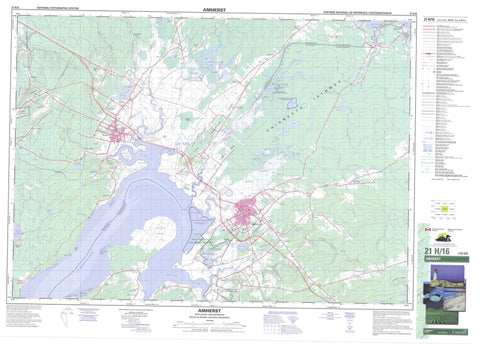
Includes UTM and GPS geographic coordinates (latitude and longitude). This 50k scale map is suitable for hiking, camping, and exploring, or you could frame it as a wall map.
Printed on-demand using high resolution, on heavy weight and acid free paper, or as an upgrade on a variety of synthetic materials.
Topos available on paper, Waterproof, Poly, or Tyvek. Usually shipping rolled, unless combined with other folded maps in one order.
- Product Number: NRCAN-021H16
- Parent Topo: TOPO-021H
- Map ID also known as: 021H16, 21H16
- Unfolded Size: Approximately 26" high by 36" wide
- Weight (paper map): ca. 55 grams
- Map Type: POD NRCAN Topographic Map
- Map Scale: 1:50,000
- Geographical region: New Brunswick, Canada
Neighboring Maps:
All neighboring Canadian topo maps are available for sale online at 1:50,000 scale.
Purchase the smaller scale map covering this area: Topo-021H
Spatial coverage:
Topo map sheet 021H16 Amherst covers the following places:
- Baie Verte - Cumberland Basin - Cumberland Basin - Downing Cove - Grande Anse - Pecks Cove - Pot Cove - Sharps Creek - Shepody Bay - Amherst Point - Black Point - Chignecto Isthmus - Chignecto Isthmus - Irvines Point - Irwin Point - Irwins Point - Jacksons Point - Minudie Point - Westmorland Point - Wood Point - Portage Run - Cumberland - Dorchester - Sackville - Westmorland - Westmorland - Coles Island - Sunken Island - Tonges Island - Big Duck Lake - Big Jolicure Lake - Black Pond - Blair Lake - Bulmers Pond - Christie Pond - Dickie Lake - Dickie Lake - Dwyers Lake - Front Lake - Frosty Hollow Lake - Funnel Lake - Goose Lake - Grass Lake - Gunners Lake - Hackmatack Lake - Halfmoon Lake - Howards Lake - Johnson Lake - Jolicure Lake - Jolicure Lakes - La Planche Lake - Large Lake - Laytons Lake - Little Duck Lake - Little Hackmatack Lake - Little Lake - Little Round Lake - Long Lake - Long Lake - McKims Hole - Morice Lake - Morice Pond - Mosleys Pond - Mud Lake - Ogdens Lake - Patten Lake - Patterson Lake - Paunchy Lake - Portage Lakes - Portage Lakes - Portey Pond - Round Lake - Rush Lake - Rush Lake - Sainsburys Hole - Sand Lake - Smith Lakes - Stoney Lake - Truemans Mill Pond - Weatherhead Lake - Wild Goose Lake - Woods Pond - Amherst Range - Champ de tir Amherst - Beech Hill - Coppermine Hill - Etter Ridge - Fort Cumberland Ridge - Fort Lawrence Ridge - Halls Hill - Jolicure Ridge - Leicester Ridge - Mount Uniacke - Uniacke Hill - Cumberland - Amherst Point Bird Sanctuary - Amherst Point Migratory Bird Sanctuary - Beaubassin National Historic Site of Canada - Chignecto National Wildlife Area - Édifice Wood - Fort Beauséjour -- Fort Cumberland National Historic Site of Canada - Fort Beauséjour National Historic Site of Canada - Fort Lawrence National Historic Site of Canada - John Lusby Marsh National Wildlife Area - La Coupe Dry Dock National Historic Site of Canada - Lieu historique national du Canada de Beaubassin - Lieu historique national du Canada de la Cale-Sèche-La Coupe - Lieu historique national du Canada du Fort Beauséjour -- Fort Cumberland - Lieu historique national du Canada du Fort-Beauséjour - Lieu historique national du Canada du Fort-Lawrence - Refuge d'oiseaux d'Amherst Point - Refuge d'oiseaux migrateurs de la Pointe-Amherst - Réserve nationale de faune de Chignecto - Réserve nationale de faune de Tintamarre - Réserve nationale de faune du marais John Lusby - Tidnish Dock Provincial Park - Tintamarre National Wildlife Area - Wood Block - New Brunswick - Nouveau-Brunswick - Nouvelle-Écosse - Nova Scotia - Warm Run - Allen Brook - Allen Creek - Aulac River - Ayers Brook - Back Brook - Baird Brook - Bakers Brook - Bakers Brook - Beaver Brook - Beherrel Brook - Big Brook - Breau Creek - Carters Brook - Chapman Brook - Clarke Brook - Clarken Brook - Cumberland Creek - Dickeys Brook - East Brook - Etter Brook - Ettors Brook - Frosty Hollow Brook - Gooden Brook - Gooden Creek - Goodwins Brook - Goose Creek - Harper Brook - Harvey Creek - Holt Mill Brook - Jenks Brook - Joe Bird Brook - Joe Brook - Johnson Creek - Keillor Brook - King Creek - La Coupe River - La Planche River - LaPlanche River - Len Buck Brook - Lime-kiln Brook - Little Forks River - Little River - Little West Branch Tidnish River - Little West Tidnish River - Log Lake Stream - Lowther Brook - Maccan River - MacLellans Brook - Mill Brook - Mill Creek - Milltown Brook - Missaguash River - Missaguash River - Morice Brook - Morice Creek - Nappan River - North Brook - Ogden Mill Brook - Oxley Creek - Paradise Brook - Portage Run - Purdy Brook - Reservoir Brook - River Hébert - Robinson Brook - Robinson Brook - Rockwell Creek - Smelt Brook - Smelt Brook - Sterling Brook - Stewarts Brook - Styles Brook - Tantramar River - The Branch Nappan River - Three Mile Brook - Tidnish River - Two Mile Brook - Twomile Brook - Vernon Creek - West Branch Tidnish River - West Tidnish River - Wood Creek - Amherst - Sackville - Aboushagan Road - Amherst Head - Amherst Point - Aulac - Aulac - Baie Verte Road - Baie-Verte Road - Barronsfield - British Settlement - Brookdale - Brooklyn Road - Cherry Burton - Coles Island - East Amherst - Evans - Fairfield - Fenwick - Fort Lawrence - Frosty Hollow - Halls Hill - Hastings - Head of Amherst - Jacksons Point - Johnson Mills - Johnson's Mills - Jolicure - Lower Maccan - Middle Sackville - Midgic - Midgic Station - Mill Creek - Minudie - Mount Uniacke - Mount View - Mount Whatley - Nappan - Nappan Station - Ogden Mill - Point de Bute - Point-de-Bute - Salem - Stanley - Tidnish - Tidnish Bridge - Tidnish Bridge - Tidnish Cross Roads - Truemanville - Tyndal Road - Uniacke Hill - Upper Nappan - Upper Point de Bute - Upper Pointe-de-Bute - Upper Rockport - Upper Sackville - Ward - Warren - West Amherst - West Leicester - West Sackville - Westcock - Wood Point - Woodhurst - Amherst Marsh - Amherst Marsh - Elysian Fields - Lusbys Marsh - Minudie Marsh - Missaguash Bog - Missaguash Bog - Ram Pasture Marsh - Tantramar Marsh - Tantramar Marshes - Westcock Marsh


