
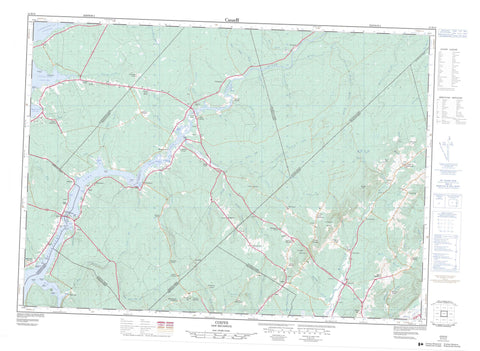
021H13 Codys Canada topo map, 1:50,000 scale
021H13 Codys NRCAN topographic map.
Includes UTM and GPS geographic coordinates (latitude and longitude). This 50k scale map is suitable for hiking, camping, and exploring, or you could frame it as a wall map.
Printed on-demand using high resolution, on heavy weight and acid free paper, or as an upgrade on a variety of synthetic materials.
Topos available on paper, Waterproof, Poly, or Tyvek. Usually shipping rolled, unless combined with other folded maps in one order.
- Product Number: NRCAN-021H13
- Parent Topo: TOPO-021H
- Map ID also known as: 021H13, 21H13
- Unfolded Size: Approximately 26" high by 36" wide
- Weight (paper map): ca. 55 grams
- Map Type: POD NRCAN Topographic Map
- Map Scale: 1:50,000
- Geographical region: New Brunswick, Canada
Neighboring Maps:
All neighboring Canadian topo maps are available for sale online at 1:50,000 scale.
Purchase the smaller scale map covering this area: Topo-021H
Spatial coverage:
Topo map sheet 021H13 Codys covers the following places:
- Big Cove - Coxs Cove - Cumberland Bay - Flowers Cove - Fowlers Cove - Gilchrist Cove - Hamms Cove - Lewis Cove - Pattersons Cove - Picketts Cove - Richardsons Cove - Rouses Cove - Starkey Cove - Todds Cove - Wiggins Cove - Wilsons Cove - Youngs Cove - Foshay Beach - Appleby Point - Barnes Point - DeWares Point - Fanjoys Point - Foster Point - Jones Point - Loon Point - Perrys Point - Redbank Point - Robinson Point - Narrow Piece - Dickson Bluff - The Bluff - The Bluff - Brunswick - Cambridge - Havelock - Johnston - Kings - Queens - Springfield - Studholm - Waterborough - Wickham - Birch Island - Coles Island - Pine Island - Grand Lake - Mud Lake - Washademoak Lake - Humphreys Wharf - Byron Hill - Gibbon Mountain - Kierstead Mountain - McMillan Hill - Morgan Hill - Pleasant Ridge - Scotch Mountain - Sharps Hill - Snider Mountain - Archdeacon Hiram A. Cody House - Maison de l'archidiacre Hiram A. Cody - Canaan Rapids - Beatty Brook - Belleisle (Pascobac) Creek - Big Brook - Cameron Brook - Canaan River - Carmichael Brook - Chapman Brook - Cole Perry Brook - Dingley Brook - Flat Rock Brook - Flowers Brook - Four Mile Brook - Harrison Brook - Harry Brook - Henderson Brook - Highfield Brook - Irish Settlement Brook - Joliff Brook - Joliffs Brook - Jolly Creek - Jonah Brook - Kelly Brook - Kennebec Brook - Lawson Brook - Lester Brook - Lewis Brook - Long Creek - McGregor Brook - McGregor Creek - McNair Brook - Middle Brook - Mill Brook - Mill Brook - Miller Brook - Millstream River - Morrison Brook - Mullaley Brook - Northeast Branch Long Creek - Northeast Branch Mill Brook - Northeast Long Creek - Northeast Mill Brook - Parks Brook - Pascobac (Belleisle) Creek - Pascobac Brook - Pascobac Creek - Pascobac Stream - Pearson Brook - Phillips Brook - Picketts Cove Brook - Porcupine Brook - Rankine Brook - Riders (Miller) Brook - Rouse Brook - Ryan Brook - Ryans Brook - Salmon Creek - Saunders Brook - Sheck Brook - Smith Creek - Smiths Creek - Snider Brook - Snyder Brook - South Branch Mill Brook - South Branch Miller Brook - South Branch Riders (Miller) Brook - South Branch Wasson Brook - South Riders (Miller) Brook - Starkey Brook - Studholm Brook - Studholm Mill Stream - Studholms Mill Stream - Wasson Brook - Watts Brook - Wilson Brook - Youngs Creek - Holms Lump - The Hedgerow - Akerly - Annidale - Bagdad - Bagdad Station - Berwick - Big Cove - Blair - Brookvale - Brownville - Cambridge - Canaan Rapids - Carsonville - Centre Millstream - Centreville - Chambres Corner - Codys - Coles Island - Collina - Cornwall - Daniel - Dixon - East Scotch Settlement - Fenwick - Gibbon - Goshen - Hammtown - Hamtown - Head of Millstream - Highfield - Irish Settlement - Kierstead Mountain - Lakeview - Long Creek - Marrtown - McDonald Corner - McGregor Brook - Mill Brook - Millstream - Mount Hebron - Mount Middleton - Narrows - Northrups Corner - Partridge Valley - Pearsonville - Perry - Phillipstown - Pleasant Ridge - Rees - Salmon Creek - Salmon Creek Settlement - Scotch Settlement - Smith Corner - Snider Mountain - Starkey - Summerfield - The Range - Thomond - Thompson - Thompson Corner - Thorne - Thornetown - Union Settlement - Upper Belleisle - Washademoak - Waterloo Corner - Youngs Cove - Youngs Cove Road - Cambridge-Narrows


