
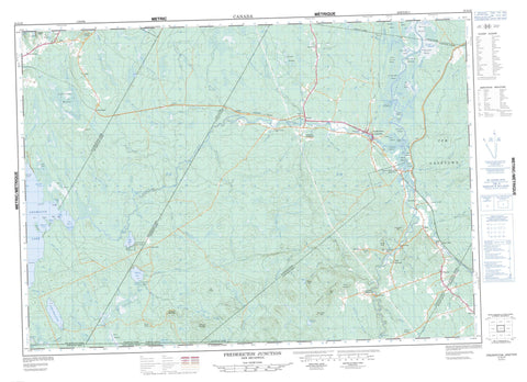
021G10 Fredericton Junction Canada topo map, 1:50,000 scale
021G10 Fredericton Junction NRCAN topographic map.
Includes UTM and GPS geographic coordinates (latitude and longitude). This 50k scale map is suitable for hiking, camping, and exploring, or you could frame it as a wall map.
Printed on-demand using high resolution, on heavy weight and acid free paper, or as an upgrade on a variety of synthetic materials.
Topos available on paper, Waterproof, Poly, or Tyvek. Usually shipping rolled, unless combined with other folded maps in one order.
- Product Number: NRCAN-021G10
- Parent Topo: TOPO-021G
- Map ID also known as: 021G10, 21G10
- Unfolded Size: Approximately 26" high by 36" wide
- Weight (paper map): ca. 55 grams
- Map Type: POD NRCAN Topographic Map
- Map Scale: 1:50,000
- Geographical region: New Brunswick, Canada
Neighboring Maps:
All neighboring Canadian topo maps are available for sale online at 1:50,000 scale.
Purchase the smaller scale map covering this area: Topo-021G
Spatial coverage:
Topo map sheet 021G10 Fredericton Junction covers the following places:
- Harbour Island Cove - Indian Cove - Round Cove - Rutherfords Cove - Sam Hoyts Cove - The Basin - Caribou Point - Deer Point - Green Point - Indian Point - Norway Point - Orrs Point - Sand Point - Kedron Thoroughfare - The Jaws - Gaspereau Falls - North Branch Falls - South Branch Falls - Blissville - Burton - Charlotte - Clarendon - Dumbarton - Gladstone - Kingsclear - Lincoln - Manners Sutton - New Maryland - Petersville - Queens - Saint George - Sunbury - Russel Dam - Basley Island - Curries Island - Harbour Island - Hartts Island - Kelly Island - MacGougans Island - Matts Island - Big Kedron Lake - Curries Pond - Grieve Lake - Halfmoon Pond - Holland Lake - Jakes Pond - Kedron Lake - Little Kedron Lake - Little Lake - McLaughlin Pond - Morrow Pond - Mud Lake - Oromocto Lake - Peltoma Lake - Second Kedron Lake - Seeley Pond - Seelys Lake - Three Tree Creek Pond - White Birch Lake - Canadian Forces Base Gagetown - Champ de tir et champ de manoeuvre Gagetown - Gagetown Range and Training Area - Bailey Hill - Bailey Rock - Big Scott Mountain - Birch Lake Mountain - Brown Ridge - Harvey Mountain - Juvenile Hills - Lewis Mountain - Little Scott Mountain - McCarrick Ridge - Mount Harvey - Oak Ridge - Porcupine Rock - Seelys Mountain - Victors Mountain - Wooden Hill - Barton Rapids - Dowdall Rips - McCarrick Rips - Back Creek - Bass Creek - Bear Brook - Beaver Brook - Ben Brook - Black Brook - Boone Brook - Brizley Stream - Carrow Brook - Charley Brook - Cranberry Brook - Crazy Brook - Dan Brook - Dead Brook - Deadwater Brook - Dorothea Creek - Douglas Brook - East Branch Lyons Stream - East Lyon Stream - Elm Brook - Elm Brook - Elm Brook - Fitch Creek - Forbes Brook - Frank Nasons Brook - Gardner Creek - Gelder Brook - Gelder Creek - Gullison Brook - Half Mile Brook - Hardwood Creek - Heron Brook - Howe Brook - Image Brook - Jewetts Creek - Kedron Brook - Kleef Brook - Little Kedron Brook - Little Meransey Brook - Little Otter Brook - Little Yoho Brook - Lyon Stream - Lyons Stream - McCrackens Brook - McDougall Brook - Meransey Boone Brook - Meransey Brook - Mersereau Stream - Mill Brook - Mill Brook - Mink Brook - Mistake Brook - Monday Brook - Monday Creek - Morrow Brook - Morrow Brook - Musquash Brook - Neals Meadow Brook - North Branch Oromocto River - Northwest Oromocto River - Nutter Brook - Oromocto River - Orrs Brook - Otter Brook - Peltoma Brook - Peltoma Outlet - Pete Brook - Piskahegan Stream - Porcupine Brook - Porcupine Stream - Rothea Brook - Sable Brook - Scribner Brook - Seelys Brook - Shaw Creek - Shields Brook - Shin Creek - Shin Creek - Sophia Brook - Sophia Creek - South Branch Oromocto River - South Branch Shin Creek - South Oromocto River - Spring Brook - Three Tree Creek - Tracy Brook - Upper Niles Brook - Yoho Stream - Acton - Bailey - Blissville - Blissville Airport - Boyne - Central Blissville - Cork - Germany - Hoyt - Hoyt Station - Hurley Corner - Juvenile Settlement - Klondike Settlement - Little Lake - Mill Settlement - Mill Settlement - Mill Settlement West - Patterson - Patterson Road - Patterson Settlement - Pleasington - Prides Landing - Roach - Rooth - Rooth Station - Sand Brook - South Branch - Three Tree Creek - Tracyville - Upper Tracy - Vespra - West Mill Settlement - Wirral - Bass Creek Meadow - Bear Brook Meadow - Big Heath - Boone Meadows - Byers Meadow - Dave McLaughlin Meadow - Fred Phillips Meadow - Hal Hartts Meadows - Little Heath - Lyons Stream Meadows - McLaughlin Meadow - Mersereau Meadow - Morrow Meadow - Neals Meadow - Porcupine Meadows - Prides Meadows - Seeley Intervale - Seeley Meadow - Shaw Creek Meadow - Shaws Meadows - Smith Mersereau Meadow - Three Tree Creek Meadow - Tom Hartts Meadows - Tracys Meadow - Wood Meadow - Fredericton Junction - Harvey - Tracy


