
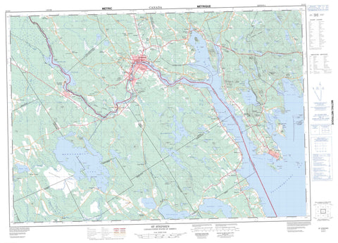
021G03 St Stephen Canada topo map, 1:50,000 scale
021G03 St Stephen NRCAN topographic map.
Includes UTM and GPS geographic coordinates (latitude and longitude). This 50k scale map is suitable for hiking, camping, and exploring, or you could frame it as a wall map.
Printed on-demand using high resolution, on heavy weight and acid free paper, or as an upgrade on a variety of synthetic materials.
Topos available on paper, Waterproof, Poly, or Tyvek. Usually shipping rolled, unless combined with other folded maps in one order.
- Product Number: NRCAN-021G03
- Parent Topo: TOPO-021G
- Map ID also known as: 021G03, 21G3, 21G03
- Unfolded Size: Approximately 26" high by 36" wide
- Weight (paper map): ca. 55 grams
- Map Type: POD NRCAN Topographic Map
- Map Scale: 1:50,000
- Geographical region: New Brunswick, Canada
Neighboring Maps:
All neighboring Canadian topo maps are available for sale online at 1:50,000 scale.
Purchase the smaller scale map covering this area: Topo-021G
Spatial coverage:
Topo map sheet 021G03 St Stephen covers the following places:
- Big Bay - Birch Cove - Bocabec Cove - Brandy Cove - Chamcook Harbour - Hanson Cove - Johnson Cove - Katys Cove - Katy's Cove - Kitty Cove - Marshalls Cove - McCann Cove - Mill Cove - Oak Bay - Pagans Cove - Passamaquoddy Bay - Port St. Andrews - Pottery Cove - Sandy Cove - St. Andrews Harbour - Tufts Cove - Long Bar - Apple Point - Berry Point - Campbell Point - Chamcook Point - Craig Point - Cranberry Point - Creighton Point - Haley Point - Hanson Point - Hills Point - Holey Point - Indian Point - Joes Point - Joe's Point - Kilmarnock Head - Long Point - Mark Point - North Point - Oak Point - Pagan Point - Pine Point - Plaisler Point - Raven Head - Ross Point - Sand Point - Sandy Point - Spruce Point - Todds Point - Chamcook Channel - The Narrows - Western Channel - Salmon Falls - Charlotte - Dufferin - Saint Andrews - Saint Croix - Saint David - Saint James - Saint Patrick - Saint Stephen - West Isles - Butler Islands - Cookson Island - Crocker Island - Hardwood Island - Hospital Island - McVicar Island - Minister Island - Ministers Island - Mosquito Island - Navy (St. Andrews) Island - Navy Island - Odell Island - Rickets Island - Spoon Island - St. Andrews Island - Bills Lake - Bocabec Lake - Bonaparte Lake - Canty Lake - Chamcook Lake - Chris Wren Lake - Cranberry Lake - Creasey Lake - Dennis Lake - Duck Lake - Eastman Lake - Gibson Lake - Goldsmiths Lake - Greenlaw Lake - Haddock Lake - Ingrams Lake - Johnson Lake - Kelly Lake - Kendricks Lake - Kerr Lake - Kerrs Lake - Limeburners Lake - Little Chamcook Lake - Long Lake - McCulloughs Pond - Morgan Lake - Mud Lake - Navigation Lake - North Lake - Potters Lake - Round Pond - Sam Orr Pond - Second Chamcook Lake - Snowshoe Lake - St. Patricks Lake - Stein Lake - Twin Lakes - Welch Lake - Wheaton Lake - Woodland Flowage - Woodland Lake - Bald Hill - Blueberry Mountain - Buchanan Hill - Burnt Hill - Chamcook Mountain - Chickahominy Mountain - Clarks Mountain - Greenlaws Mountain - Grimmers Mountain - Haleys Hill - Hansons Hill - Hartford Mountain - Libbys Hill - Lily Hill - Russell Ridge - Sheas Hill - Shorts Mountain - Simpson Hill - St. Croix Mountain - Todds Mountain - Wileys Mountain - Bureau de l'enregistrement du comté de Charlotte - Charlotte County Court House - Charlotte County Gaol - Charlotte County Registry Office - Dunn McQuoid House - Gladstone Smith House - Hansen House - Lieu historique international de l'Île-Sainte-Croix - Lieu historique national du Canada du Blockhaus-de-St. Andrews - Maison de Gladstone Smith - Maison de Hansen - Maison de Pagan-O'Neil - Maison du shérif Andrews - Maison Dunn McQuoid - Minister's Island - Oak Bay Provincial Park - Pagan Point - Pagan-O'Neil House - Palais de justice du comté de Charlotte - Prison du comté de Charlotte - Saint Croix Island International Historic Site - Sheriff Andrews House - St. Andrews Blockhouse National Historic Site of Canada - Bailey Rips - Allen Brook - Ash Brook - Berry Brook - Billy Weston Brook - Bush Brook - Campbell Brook - Campbell Brook - Campbells Brook - Chamcook Stream - Cottrell Brook - Dawsons Brook - Dennis Stream - Denny Stream - Doodle Brook - Gallop Stream - Goldsmiths Stream - Greenlaws Brook - Huckleberry Brook - James Brook - John Orr Brook - Little Trout Brook - Mahannas Stream - McCarley Brook - Meadow Brook - Meadow Brook - Mitchell Brook - Mohannas Creek - Mohannas Stream - Mohannes Stream - Pagans Mill Stream - Pottery Creek - Pout Brook - Smith Brook - Soap Brook - St. Croix River - Strachan Brook - Taggarts Brook - Waweig River - Big Rock - Black Rock - Cochrane Rocks - Navy Bar - Navy Bar - Navy Island Shoal - Niger Reef - Short Bar - Tongue Shoal - Saint Andrews - St. Stephen - Bar Road - Barter Settlement - Bartlett - Bartletts Mills - Bay Road - Bayside - Benson Corner - Blackland - Bocabec Cove - Burnt Hill - Chamcook - Chamcook Lake - Champlain - Crocker Hill - Dougherty - Edwards Corner - Five Corners - Four Corners - Gilmans Corner - Heathland - Kerrs Ridge - Lower Bayside - Lower Little Ridge - Maxwell - Maxwell Crossing - Mayfield - Milltown - Mohannes - Oak Bay - Oak Haven - Old Ridge - Pomeroy Landing - Simpson Corner - St. Andrews North - The Ledge - Union Mills - Upper Bayside - Upper Little Ridge - Upper Mills - Valley Road - Waweig - Wileys Corner


