
Nebraska, Physical Wall Map by Raven Maps
Detailed physical wall map of Nebraska State at a scale of 1:500,000.
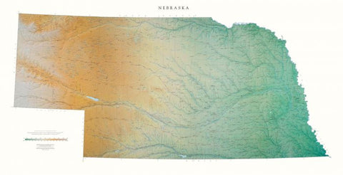
The cartography shows relief through a stunning, highly detailed shading, with different elevations varying in color, giving an almost 3-dimensional feel to the map. Peak heights are also clearly marked.
The map displays land only within the boundaries of the chosen states - there is no overlap with neighboring states. Principal physical features such as glaciers, mountain ranges, rivers and lakes are shown clearly. Human features, such as main towns, cities, roads and railways, are shown in a very fine, subtle and elegant cartographic style. State capitals are also clearly marked.
This map measures 84 x 163cm (33 x 64). The land west of the Missouri River is beautiful farm country, with streams and rivers crossing between rolling hills. The Platte river runs through the entire state, and just north of it are the Sand Hills, the largest area of sand dunes in North America.
- Product Number: 2030686M
- Product Code: RP_NE_WA
- ISBN: 9780783433141
- Year of Publication: 2002
- Map type: Wall Map
- Geographical region: Nebraska


