Free Shipping on map orders over $300 - Prices in US$
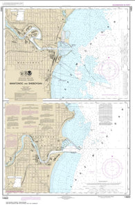
Manitowoc and Sheboygan (14922-20) by NOAA
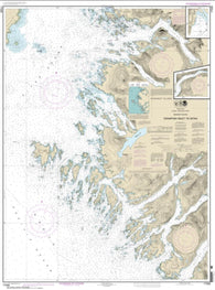
Crawfish Inlet to Sitka, Baranof I.; Sawmill Cove (17326-17) by NOAA
Revillagigedo Channel, Nichols Passage, and Tongass Narrows; Seal Cove; Ward Cove (17428-11) by NOAA
Revillagigedo Channel; Ryus Bay; Foggy Bay (17434-14) by NOAA
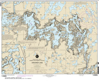
Crooked Lake (14989-10) by NOAA
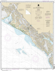
Cross Sound to Yakutat Bay (16760-10) by NOAA
Mare Island Strait (18655-59) by NOAA
Crystal River to Horseshoe Point; Suwannee River; Cedar Keys (11408-29) by NOAA
Mariana Islands Apra Harbor, Guam (81054-16) by NOAA
Mariana Islands Island of Guam Territory of Guam; Cocos Lagoon (81048-10) by NOAA
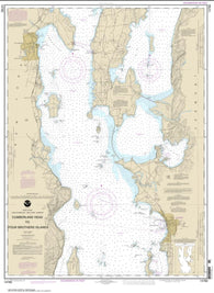
Riviere Richelieu to South Hero Island (14781-20) by NOAA
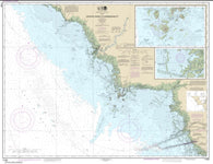
Cumberland Head to Four Brothers Islands (14782-25) by NOAA
Rochester Harbor, including Genessee River to head of navigation (14815-24) by NOAA
Marmot Bay and Kupreanof Strait; Whale Passage; Ouzinkie Harbor (16594-14) by NOAA
Maro Reef (19441-8) by NOAA
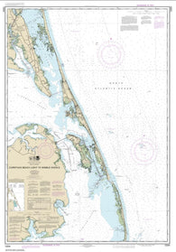
Currituck Beach Light to Wimble Shoals (12204-38) by NOAA
Marquette and Presque Isle Harbors (14970-27) by NOAA
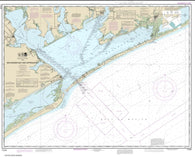
Rollover Bayou to Calcasieu Pass (11344-40) by NOAA
Marthas Vineyard Eastern Part; Oak Bluffs Harbor; Vineyard Haven Harbor; Edgartown Harbor (13238-16) by NOAA
Marthas Vineyard; Menemsha Pond (13233-19) by NOAA
Rosario Stait to Cherry Point (18431-9) by NOAA
Rosario Strait-northern part (18430-9) by NOAA
Rosario Strait-southern part (18429-11) by NOAA
Dakavak Bay to Cape Unalishagvak; Alinchak Bay (16575-2) by NOAA
Marthas Vineyard to Block Island (13218-42) by NOAA
Round I., N.Y., and Gananoque, Ont., to Wolfe I., Ont. (14774-17) by NOAA
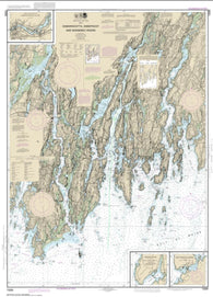
Damariscotta, Sheepscot and Kennebec Rivers; South Bristol Harbor; Christmas Cove (13293-35) by NOAA
Davidson Inlet and Sea Otter Sound; Edna Bay (17403-15) by NOAA
Massachusetts Bay; North River (13267-36) by NOAA
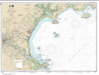
Sabine and Neches Rivers (11343-39) by NOAA
Massacre Bay (16432-12) by NOAA
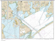
Sabine Bank (11332-33) by NOAA
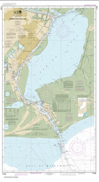
Sabine Pass and Lake (11342-55) by NOAA
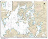
Matagorda Bay and approaches (11316-42) by NOAA
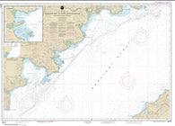
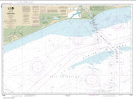
Saco Bay and Vicinity (13287-13) by NOAA
Sacramento and San Joaquin Rivers Old River, Middle River and San Joaquin River extension; Sherman Island (18661-30) by NOAA
Matagorda Bay including Lavaca and Tres Palacios Bays; Port Lavaca; Continuation of Lavaca River; Continuation of Tres Palacios Bay (11317-33) by NOAA
Sacramento River Andrus Island to Sacramento (18662-22) by NOAA
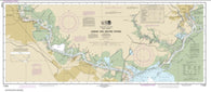
Sacramento River Fourmile Bend To Colusa (18667-12) by NOAA
Matagorda Light to Aransas Pass (11313-24) by NOAA