Free Shipping on map orders over $300 - Prices in US$
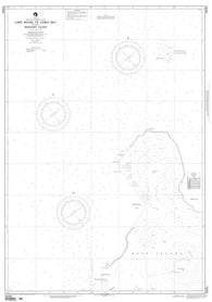
Cape Herlacher To Matha Strait (NGA-29005-7) by National Geospatial-Intelligence Agency
Java Sea (NGA-72000-8) by National Geospatial-Intelligence Agency
Palau Island - Northern Part (West Caroline Islands) (NGA-81145-1) by National Geospatial-Intelligence Agency
Palau Islands (Caroline Islands) (NGA-81141-5) by National Geospatial-Intelligence Agency
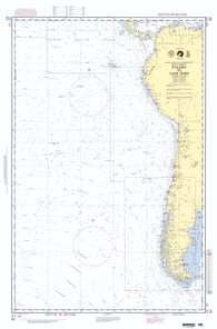
Panama To Bahia Pina (NGA-21605-7) by National Geospatial-Intelligence Agency
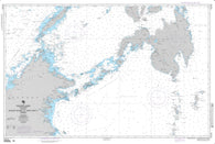
Panama To Cape Horn And The South Pacific (NGA-62-3) by National Geospatial-Intelligence Agency
Parker Snow Bugt To Kap Abernathy (NGA-38342-1) by National Geospatial-Intelligence Agency
Passages Between Acklins Islands, Haiti (NGA-26260-5) by National Geospatial-Intelligence Agency
Jucaro To Cayos Gitanos (NGA-27201-13) by National Geospatial-Intelligence Agency
Kagoshima Wan To Amami Oshima (NGA-97440-8) by National Geospatial-Intelligence Agency
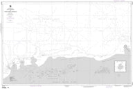
Kalingapatam To Goyangyi Kyun (Indian Ocean) (NGA-63020-15) by National Geospatial-Intelligence Agency
Cape Norvegia To Riiser-Larson Peninsula (NGA-29025-3) by National Geospatial-Intelligence Agency
Kampong Saom (NGA-93283-5) by National Geospatial-Intelligence Agency
Kara Sea To Bering Strait (Arctic) (NGA-800-4) by National Geospatial-Intelligence Agency
Karachi To Bombay (India) (NGA-63000-13) by National Geospatial-Intelligence Agency
Cape Royds To Hut Point (NGA-29322-3) by National Geospatial-Intelligence Agency
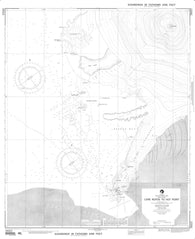
Cape Royds To Lewis Bay Including Beaufort Island (NGA-29281-1) by National Geospatial-Intelligence Agency
Persian Gulf (NGA-62032-16) by National Geospatial-Intelligence Agency
Philippine Islands - Southern Part (NGA-92006-5) by National Geospatial-Intelligence Agency
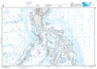
Philippines Central Part (NGA-91005-6) by National Geospatial-Intelligence Agency
Kepulauan Bone Rate To Selat Peleng (NGA-73008-8) by National Geospatial-Intelligence Agency
Kepulauan Schouten To Teluk Yos Sudarso (NGA-73030-4) by National Geospatial-Intelligence Agency
Kepulauan Tukangbesi To Kepulauan Sula (NGA-73010-3) by National Geospatial-Intelligence Agency
Pilon To La Marea Del Portillo (NGA-27222-11) by National Geospatial-Intelligence Agency
Key West To San Juan (NGA-27005-4) by National Geospatial-Intelligence Agency
Caribbean Sea - Eastern Part (NGA-25001-7) by National Geospatial-Intelligence Agency
King George Island To Clarence Island (NGA-29104-4) by National Geospatial-Intelligence Agency
Caribbean Sea - Northwest Part (NGA-28004-1) by National Geospatial-Intelligence Agency
King George Island To Corry Island (NGA-29105-5) by National Geospatial-Intelligence Agency
Caribbean Sea - Southwest Part (NGA-28006-1) by National Geospatial-Intelligence Agency
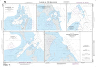
Plans In Haiti; Plan A: Mole Saint Nicolas (NGA-26147-31) by National Geospatial-Intelligence Agency
Plans In Southeastern Bahamas; Plan A: Mayaguana Island (NGA-26263-3) by National Geospatial-Intelligence Agency
Plans In The Bahamas; Plan A: Highbourn Cut (NGA-26257-15) by National Geospatial-Intelligence Agency
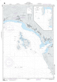
Plans In The Golfe De La Gonave; Plan A: Saint-Marc (NGA-26188-11) by National Geospatial-Intelligence Agency
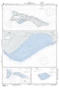
Plans Of Namonuito Islands (East Caroline Islands) (NGA-81288-1) by National Geospatial-Intelligence Agency
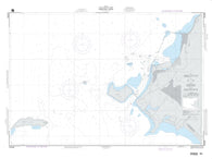
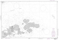
Plans Of The Marshall Islands; Plan A: Ebon Atoll (NGA-81030-5) by National Geospatial-Intelligence Agency
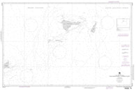
Plans On Antarctic Peninsula And Adjacent Islands; Plan F: Adelaide Anchorage (NGA-29106-5) by National Geospatial-Intelligence Agency
Plans On The North Coast Of Cuba; Panel A: Bahia De Sagua De Tanamo (NGA-26245-16) by National Geospatial-Intelligence Agency
Plans On The North Coast Of Cuba; Plan A: Puerto Gibara (NGA-26250-18) by National Geospatial-Intelligence Agency
Caroline Islands - Western Part (NGA-81002-6) by National Geospatial-Intelligence Agency