
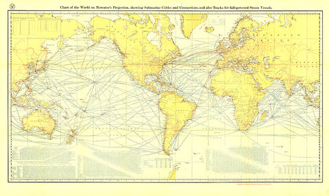
1905 Chart of the World on Mercators Projection
Submarine cables have played an important part in the development of world-wide communications since the 1850s. National Geographic first charted these cables in 1896. In comparison to that earlier map, this map, published in February 1905 reveals the explosion of communications infrastructure worldwide at the beginning of the last century.
- Product Number: PODHNG_WOR_MERC_05
- Reference Product Number: 2321718M
- ISBN: - None -
- Date of Publication: 6/1/1905
- Unfolded (flat) Size: 27.75 inches high by 46.75 inches wide
- Map format: Wall
- Map type: Trade Maps - Wall Art


