
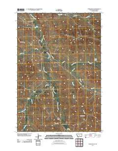
~ Forks Ranch MT topo map, 1:24000 scale, 7.5 X 7.5 Minute, Historical, 2011
Forks Ranch, Montana, USGS topographic map dated 2011.
Includes geographic coordinates (latitude and longitude). This topographic map is suitable for hiking, camping, and exploring, or framing it as a wall map.
Printed on-demand using high resolution imagery, on heavy weight and acid free paper, or alternatively on a variety of synthetic materials.
Topos available on paper, Waterproof, Poly, or Tyvek. Usually shipping rolled, unless combined with other folded maps in one order.
- Product Number: USGS-5270545
- Free digital map download (high-resolution, GeoPDF): Forks Ranch, Montana (file size: 16 MB)
- Map Size: please refer to the dimensions of the GeoPDF map above
- Weight (paper map): ca. 55 grams
- Map Type: POD USGS Topographic Map
- Map Series: US Topo
- Map Verison: Historical
- Cell ID: 15826
- Datum: North American Datum of 1983
- Map Projection: Transverse Mercator
- Map Cell Name: Forks Ranch
- Grid size: 7.5 X 7.5 Minute
- Date on map: 2011
- Map Scale: 1:24000
- Geographical region: Montana, United States
Neighboring Maps:
All neighboring USGS topo maps are available for sale online at a variety of scales.
Spatial coverage:
Topo map Forks Ranch, Montana, covers the geographical area associated the following places:
- 09S43E12ADBD01 Well - 08S44E19CBCB03 Well - West Prong Hanging Woman Creek - 09S43E15CDAB01 Well - 10S43E02BAAA01 Well - 08S43E23CABD02 Well - Forks Ranch - 09S43E22ACCA01 Well - 08S43E23DBDB01 Well - 08S43E23CACA03 Well - Negro Draw - 09S44E07BBCC01 Well - 09S43E21AADA01 Well - 10S43E02AABA01 Well - Corral Creek - 08S44E19CBCC01 Well - 09S43E21BADA02 Well - 09S43E03CBCD01 Well - 09S44E07BBCC02 Well - 09S43E02BBBB01 Well - 08S43E25DBBB02 Well - North Fork Waddle Creek - Hellers Peak - West Prong Hanging Woman Creek - East Trail Creek - Fricker Draw - 09S44E06BBBB02 Well - 08S44E19CBBB01 Well - Canyon Springs Draw - 10S43E02ACDC01 Well - 09S43E04ACAA01 Well - 09S43E04ABDD03 Well - 09S44E07BBCC04 Well - First Creek - 09S43E27CDCA01 Well - 10S43E02AACB01 Well - 08S44E19CBBB02 Well - 09S43E02BBBB02 Well - 09S43E03CBCD02 Well - Mull Draw - 09S43E35BBCD01 Well - 08S43E32BBDA01 Well - 09S43E27DABB01 Well - 09S43E10BBAD01 Well - 09S43E27AAAC01 Well - 09S43E29DBAB01 Well - 09S43E15DABC01 Well - 09S43E04CBAB01 Well - 09S44E07BBCC03 Well - 08S43E23CACA01 Well - 08S43E29DABC01 Well - Deadman Draw - 08S43E23CACA02 Well - Deep Creek - 09S43E04CBAB02 Well - 08S44E19CBCB02 Well - Old Flat Top - Waddle Creek - 09S43E12AACC01 Well - 09S43E12AACC02 Well - 08S43E23CDAA02 Well - Trail Creek - 09S43E04ABDD01 Well - 09S43E13BCAA01 Well - 08S43E23CDAA01 Well - 09S43E25BADC01 Spring - 08S43E23CABD01 Well - 08S44E19CBBD01 Well - 08S44E19CBCB01 Well - 10S43E02ABDA01 Well - 09S43E04ABDB01 Well - 10S43E02ACDA01 Well - 09S44E06BBBB01 Well - 09S43E21BADA01 Well - 09S43E13CAAA01 Well - 09S43E13CAAA02 Well - 09S43E35CADC01 Well - 09S43E04ABDD02 Well - 08S43E20DABA01 Well - 09S43E14DDBB01 Well - 09S43E12ADBB01 Well - 08S43E23DBCC01 Well - 10S43E02AABD01 Well - 09S43E04ABCA01 Well - 08S43E28CACD01 Well - Hampton Butte - 08S43E25DBBB01 Well - 09S43E12ADBB02 Well - John Reavis Draw - Lieutenant Draw
- Map Area ID: AREA45.12545-106.5-106.375
- Northwest corner Lat/Long code: USGSNW45.125-106.5
- Northeast corner Lat/Long code: USGSNE45.125-106.375
- Southwest corner Lat/Long code: USGSSW45-106.5
- Southeast corner Lat/Long code: USGSSE45-106.375
- Northern map edge Latitude: 45.125
- Southern map edge Latitude: 45
- Western map edge Longitude: -106.5
- Eastern map edge Longitude: -106.375


