
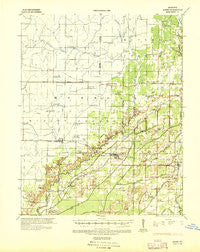
~ Acorn MO topo map, 1:62500 scale, 15 X 15 Minute, Historical, 1935, updated 1936
Acorn, Missouri, USGS topographic map dated 1935.
Includes geographic coordinates (latitude and longitude). This topographic map is suitable for hiking, camping, and exploring, or framing it as a wall map.
Printed on-demand using high resolution imagery, on heavy weight and acid free paper, or alternatively on a variety of synthetic materials.
Topos available on paper, Waterproof, Poly, or Tyvek. Usually shipping rolled, unless combined with other folded maps in one order.
- Product Number: USGS-5679593
- Free digital map download (high-resolution, GeoPDF): Acorn, Missouri (file size: 6 MB)
- Map Size: please refer to the dimensions of the GeoPDF map above
- Weight (paper map): ca. 55 grams
- Map Type: POD USGS Topographic Map
- Map Series: HTMC
- Map Verison: Historical
- Cell ID: 58297
- Scan ID: 324674
- Imprint Year: 1936
- Woodland Tint: Yes
- Survey Year: 1929
- Datum: NAD
- Map Projection: Polyconic
- Map published by United States Army Corps of Engineers
- Map published by United States Department of War
- Map Language: English
- Scanner Resolution: 600 dpi
- Map Cell Name: Naylor
- Grid size: 15 X 15 Minute
- Date on map: 1935
- Map Scale: 1:62500
- Geographical region: Missouri, United States
Neighboring Maps:
All neighboring USGS topo maps are available for sale online at a variety of scales.
Spatial coverage:
Topo map Acorn, Missouri, covers the geographical area associated the following places:
- Dryden (historical) - Parks - Gheen - Kremlin Mill - Paterson Ford - Sinsabaugh - Taft - Flatwoods - Naylor - Booser (historical) - Martinsburg (historical) - Kingbee (historical) - Greenville Ford - Riga (historical) - Roxie (historical) - Glenn - Oxly - Fairdealing - Belcher (historical) - Pulaski - Hubbells - Neelyville - Hemenway - Gamburg - Torch - Purman - Lone Hill - Sims (historical)
- Map Area ID: AREA36.7536.5-90.75-90.5
- Northwest corner Lat/Long code: USGSNW36.75-90.75
- Northeast corner Lat/Long code: USGSNE36.75-90.5
- Southwest corner Lat/Long code: USGSSW36.5-90.75
- Southeast corner Lat/Long code: USGSSE36.5-90.5
- Northern map edge Latitude: 36.75
- Southern map edge Latitude: 36.5
- Western map edge Longitude: -90.75
- Eastern map edge Longitude: -90.5


