
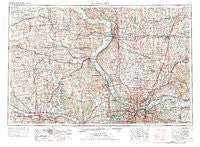
~ Kansas City MO topo map, 1:250000 scale, 1 X 2 Degree, Historical, 1956, updated 1976
Kansas City, Missouri, USGS topographic map dated 1956.
Includes geographic coordinates (latitude and longitude). This topographic map is suitable for hiking, camping, and exploring, or framing it as a wall map.
Printed on-demand using high resolution imagery, on heavy weight and acid free paper, or alternatively on a variety of synthetic materials.
Topos available on paper, Waterproof, Poly, or Tyvek. Usually shipping rolled, unless combined with other folded maps in one order.
- Product Number: USGS-5575888
- Free digital map download (high-resolution, GeoPDF): Kansas City, Missouri (file size: 24 MB)
- Map Size: please refer to the dimensions of the GeoPDF map above
- Weight (paper map): ca. 55 grams
- Map Type: POD USGS Topographic Map
- Map Series: HTMC
- Map Verison: Historical
- Cell ID: 68851
- Scan ID: 325601
- Imprint Year: 1976
- Woodland Tint: Yes
- Aerial Photo Year: 1973
- Edit Year: 1974
- Field Check Year: 1956
- Datum: Unstated
- Map Projection: Transverse Mercator
- Map published by United States Geological Survey
- Map published by: Military, Other
- Map Language: English
- Scanner Resolution: 600 dpi
- Map Cell Name: Kansas City
- Grid size: 1 X 2 Degree
- Date on map: 1956
- Map Scale: 1:250000
- Geographical region: Missouri, United States
Neighboring Maps:
All neighboring USGS topo maps are available for sale online at a variety of scales.
Spatial coverage:
Topo map Kansas City, Missouri, covers the geographical area associated the following places:
- Boyle - Gower - Millwood - Plainview - Far West - Liberty - Nodaway - Cowpoke Mobile Home Park - Maywood - Winchester - Tonganoxie - Tarrytown - Camden - Excelsior Springs - Clarksdale - Brenner - Easton - Little Kaw - Soldier - Coldspur - Effingham - Parkdale - Morrill - Bern - Holt - Meadowood Mobile Home Park - Glenaire - Woodruff - Horton - Westbridge - Rushville - New Market - Piper - Mosby - Silver Lake - Hemple - Victory Junction - Arrington - Rock Creek - Atherton - Hoover - Mission Woods - Maple Hill - Countryside - Liberty Landing (historical) - White Hall Fields - Jarbalo - Fairmount - Mock Corner - Wallula - River View Mobile Country Club - Cameron - Lake City - Tecumseh - New Garden - Westwood - Alta Vista - Air Line Junction - Sunflower - Manchester School - Nearman - Starfield - Delia - Kerrville - Woodmoor Mobile Home Park - Wadsworth - Platte Woods - Doniphan - Scearces - Lansing - Crystal Lakes - Larkinburg - Milton - Elwood - Denton - Newman - Robinson - Dalbey - Wallace - Gashland - Kingston - Sunflower Village Mobile Home Park - East Independence - Curzon - Merriam - Breen Acres - Cummings - Stony Point - Mirabile - Hurlingen - Circleville - Kerr - Valley Falls - Oneida - Lilly - Bendena - Coopers - Capioma - Greenwood - Cobbler
- Map Area ID: AREA4039-96-94
- Northwest corner Lat/Long code: USGSNW40-96
- Northeast corner Lat/Long code: USGSNE40-94
- Southwest corner Lat/Long code: USGSSW39-96
- Southeast corner Lat/Long code: USGSSE39-94
- Northern map edge Latitude: 40
- Southern map edge Latitude: 39
- Western map edge Longitude: -96
- Eastern map edge Longitude: -94


