
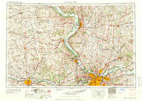
~ Kansas City MO topo map, 1:250000 scale, 1 X 2 Degree, Historical, 1960
Kansas City, Missouri, USGS topographic map dated 1960.
Includes geographic coordinates (latitude and longitude). This topographic map is suitable for hiking, camping, and exploring, or framing it as a wall map.
Printed on-demand using high resolution imagery, on heavy weight and acid free paper, or alternatively on a variety of synthetic materials.
Topos available on paper, Waterproof, Poly, or Tyvek. Usually shipping rolled, unless combined with other folded maps in one order.
- Product Number: USGS-5575882
- Free digital map download (high-resolution, GeoPDF): Kansas City, Missouri (file size: 22 MB)
- Map Size: please refer to the dimensions of the GeoPDF map above
- Weight (paper map): ca. 55 grams
- Map Type: POD USGS Topographic Map
- Map Series: HTMC
- Map Verison: Historical
- Cell ID: 68851
- Scan ID: 325598
- Woodland Tint: Yes
- Visual Version Number: 1
- Field Check Year: 1956
- Datum: Unstated
- Map Projection: Transverse Mercator
- Map published by United States Army Corps of Engineers
- Map published by United States Army
- Map Language: English
- Scanner Resolution: 600 dpi
- Map Cell Name: Kansas City
- Grid size: 1 X 2 Degree
- Date on map: 1960
- Map Scale: 1:250000
- Geographical region: Missouri, United States
Neighboring Maps:
All neighboring USGS topo maps are available for sale online at a variety of scales.
Spatial coverage:
Topo map Kansas City, Missouri, covers the geographical area associated the following places:
- Kidder - West Keystone - Willow Brook - Sandals - Grinter Heights - New Garden - Parkville - Glenaire - Pleasant Valley - Alta Vista - Maxey - North Ridge Mobile Home Park - Lake Shore - Camden - Rock Creek Junction - Golf Hill - Powhattan - Manchester School - Centropolis - Sabetha - Countryside - Richardson - Grover - Fleming - Fidelity - Baker - Atherton - Bethel - Fairport - Blue Springs - Kyle - Clear Creek Court Mobile Home Park - Cummings - Liberty Landing (historical) - Whiting - Oak - Tracy - Kiro - Five Points - Lake City - Kennekuk - Millwood - Wallula - Woodhill - Hoyt - Haynesville - Oak Grove - East Leavenworth - Raytown - Dean - Air Line Junction - Nortonville - Agency - Mahon - Paradise - Converse - Grandview - Hampton - Big Springs - Plainview - Lancaster - Platte Gardens - Independence - Linwood - Winner - Richie - Lilly - Gaslight Mobile Home Park - Savannah - Willis - Midland - Grove Center - Prathersville - Wildwoods Mobile Home Park - Mission - Goff - Little Kaw - Mock Corner - Lecompton - Faucett - Curzon - Vinewood - Matney - Polo - Leona - Knoxville - Country Hills Manufactured Home Community - Lansing - Denison - Delaney - Breen Acres - Starfield - Richville - Grain Valley - Birmingham - Newman - Maple Garden - Bonner Springs Estates Mobile Home Park - Tecumseh - Sunflower Trailer Park
- Map Area ID: AREA4039-96-94
- Northwest corner Lat/Long code: USGSNW40-96
- Northeast corner Lat/Long code: USGSNE40-94
- Southwest corner Lat/Long code: USGSSW39-96
- Southeast corner Lat/Long code: USGSSE39-94
- Northern map edge Latitude: 40
- Southern map edge Latitude: 39
- Western map edge Longitude: -96
- Eastern map edge Longitude: -94


