
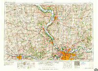
~ Kansas City MO topo map, 1:250000 scale, 1 X 2 Degree, Historical, 1960, updated 1960
Kansas City, Missouri, USGS topographic map dated 1960.
Includes geographic coordinates (latitude and longitude). This topographic map is suitable for hiking, camping, and exploring, or framing it as a wall map.
Printed on-demand using high resolution imagery, on heavy weight and acid free paper, or alternatively on a variety of synthetic materials.
Topos available on paper, Waterproof, Poly, or Tyvek. Usually shipping rolled, unless combined with other folded maps in one order.
- Product Number: USGS-5575880
- Free digital map download (high-resolution, GeoPDF): Kansas City, Missouri (file size: 23 MB)
- Map Size: please refer to the dimensions of the GeoPDF map above
- Weight (paper map): ca. 55 grams
- Map Type: POD USGS Topographic Map
- Map Series: HTMC
- Map Verison: Historical
- Cell ID: 68851
- Scan ID: 325597
- Imprint Year: 1960
- Woodland Tint: Yes
- Field Check Year: 1956
- Datum: Unstated
- Map Projection: Transverse Mercator
- Map published by United States Army Corps of Engineers
- Map published by United States Army
- Map Language: English
- Scanner Resolution: 600 dpi
- Map Cell Name: Kansas City
- Grid size: 1 X 2 Degree
- Date on map: 1960
- Map Scale: 1:250000
- Geographical region: Missouri, United States
Neighboring Maps:
All neighboring USGS topo maps are available for sale online at a variety of scales.
Spatial coverage:
Topo map Kansas City, Missouri, covers the geographical area associated the following places:
- Tonganoxie - Countryside Home Park Mobile Home Park - Kickapoo - White Hall Fields - Barwick - Half Mound - Waldron - Farmington - Rushville - Hiler - Curzon - Woodhill - Turner - Kerrville - Lake City - Holton - Sugar Lake - Midland - Stockdale - Dye - Boxford (historical) - Camden Point - Parkdale - Hilldale - Osborn - Haynesville - Winston - Chick (historical) - Civil Bend - S and J Estates Mobile Home Park - Tiffany Springs - Everest - Maywood - Kodiak - Fairmount - Winchester - Cobbler - Homestead - Holliday - Fairway - Platte Gardens - Faucett - Adams Heights Mobile Home Park - Fidelity - Min - Rock Village - Frisbie - Caravan Mobile Park - Hampton - Stony Point - Reno - Starfield - Houston Lake - Easton - Whiting - Morris - Sparks - Raytown - Edwardsville Mobile Home Village - Pleasant Valley - Perry Plaza Court Mobile Home Park - Vinewood - Elmira - Leavenworth - Glenaire - Port Williams - Winner - Fairview - Nodaway - Forest City - Moray - Boyle - Wathena - Grantville - Rossville - Chandler - Padonia - Larkinburg - Delaney - Kiro - Air Line Junction - Fairport - Ettenson - Scearces - Elmont - Adams - Westport - Kyle - Hilldale South - Atchison - Kearney - Ontario - Maysville - Agency - Manchester School - Stubbs - Woodmoor Mobile Home Park - Kidder - Waterloo - Ectonville - Evanston
- Map Area ID: AREA4039-96-94
- Northwest corner Lat/Long code: USGSNW40-96
- Northeast corner Lat/Long code: USGSNE40-94
- Southwest corner Lat/Long code: USGSSW39-96
- Southeast corner Lat/Long code: USGSSE39-94
- Northern map edge Latitude: 40
- Southern map edge Latitude: 39
- Western map edge Longitude: -96
- Eastern map edge Longitude: -94


