
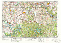
~ Jefferson City MO topo map, 1:250000 scale, 1 X 2 Degree, Historical, 1955, updated 1973
Jefferson City, Missouri, USGS topographic map dated 1955.
Includes geographic coordinates (latitude and longitude). This topographic map is suitable for hiking, camping, and exploring, or framing it as a wall map.
Printed on-demand using high resolution imagery, on heavy weight and acid free paper, or alternatively on a variety of synthetic materials.
Topos available on paper, Waterproof, Poly, or Tyvek. Usually shipping rolled, unless combined with other folded maps in one order.
- Product Number: USGS-5575864
- Free digital map download (high-resolution, GeoPDF): Jefferson City, Missouri (file size: 24 MB)
- Map Size: please refer to the dimensions of the GeoPDF map above
- Weight (paper map): ca. 55 grams
- Map Type: POD USGS Topographic Map
- Map Series: HTMC
- Map Verison: Historical
- Cell ID: 68843
- Scan ID: 325590
- Imprint Year: 1973
- Woodland Tint: Yes
- Visual Version Number: 1
- Aerial Photo Year: 1950
- Edit Year: 1970
- Field Check Year: 1955
- Datum: Unstated
- Map Projection: Transverse Mercator
- Map published by United States Army Corps of Engineers
- Map published by United States Army
- Map Language: English
- Scanner Resolution: 600 dpi
- Map Cell Name: Jefferson City
- Grid size: 1 X 2 Degree
- Date on map: 1955
- Map Scale: 1:250000
- Geographical region: Missouri, United States
Neighboring Maps:
All neighboring USGS topo maps are available for sale online at a variety of scales.
Spatial coverage:
Topo map Jefferson City, Missouri, covers the geographical area associated the following places:
- Dixie - Guthrie - Macks Camp - Columbia - Round Bottom Ford (historical) - Pleasant Green - Stephens - Sapp - Palo Pinto - Florence - Denton - Garland - Venus - Avery - Lake Mykee Town - Kliever - Ohio - Pertle Springs - Sandy Hook - La Monte - Etterville - California - Todd (historical) - Leesville - White Cloud - Marys Home - Old Linn Creek - Mount Zion - Hereford - Mount Pleasant - Bentonville - Chalk Level - Bryson - Consville (historical) - Atwell - Arrowhead - Stover - Lincoln - Roseland - West Aurora - Saint Anthony - Cornelia - Koeltztown - Enon - Delmar - Lakeview - Livingston - Eastville - Smithton (historical) - Sparrow - Petersburg (historical) - Shantytown - Jordan - Petersburg - North Jefferson - Big Bend - Hartwell - Kaiser - Gabriels Mills - Henrietta - Eugene - Sedalia - Hastain - Hurricane Deck - Carrington - Green Ridge - Ellerslie (historical) - Windsor Place - Olean - Damsel - Henley - Summerville (historical) - Bannister Ford - Ginlet - Cole Camp Junction - Blackwater (historical) - Bunceton - Bowmansville - Manila - Englewood - Buck Creek - Scruggs - Sunrise Beach - Saint Thomas - Dell - Wilton - Keethtown - Midway - Wainwright - Hoffman - Harg - Overton - Shaw - Old Chilhowee - Lindbergh - Mount Olive - Phillips Ford (historical) - Ashland - Wardsville - Prairie Home
- Map Area ID: AREA3938-94-92
- Northwest corner Lat/Long code: USGSNW39-94
- Northeast corner Lat/Long code: USGSNE39-92
- Southwest corner Lat/Long code: USGSSW38-94
- Southeast corner Lat/Long code: USGSSE38-92
- Northern map edge Latitude: 39
- Southern map edge Latitude: 38
- Western map edge Longitude: -94
- Eastern map edge Longitude: -92


