
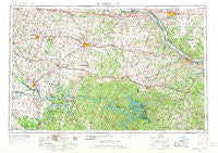
~ Jefferson City MO topo map, 1:250000 scale, 1 X 2 Degree, Historical, 1955, updated 1967
Jefferson City, Missouri, USGS topographic map dated 1955.
Includes geographic coordinates (latitude and longitude). This topographic map is suitable for hiking, camping, and exploring, or framing it as a wall map.
Printed on-demand using high resolution imagery, on heavy weight and acid free paper, or alternatively on a variety of synthetic materials.
Topos available on paper, Waterproof, Poly, or Tyvek. Usually shipping rolled, unless combined with other folded maps in one order.
- Product Number: USGS-5575860
- Free digital map download (high-resolution, GeoPDF): Jefferson City, Missouri (file size: 22 MB)
- Map Size: please refer to the dimensions of the GeoPDF map above
- Weight (paper map): ca. 55 grams
- Map Type: POD USGS Topographic Map
- Map Series: HTMC
- Map Verison: Historical
- Cell ID: 68843
- Scan ID: 325588
- Imprint Year: 1967
- Woodland Tint: Yes
- Aerial Photo Year: 1950
- Edit Year: 1967
- Field Check Year: 1955
- Datum: Unstated
- Map Projection: Transverse Mercator
- Map published by United States Army Corps of Engineers
- Map published by United States Army
- Map Language: English
- Scanner Resolution: 600 dpi
- Map Cell Name: Jefferson City
- Grid size: 1 X 2 Degree
- Date on map: 1955
- Map Scale: 1:250000
- Geographical region: Missouri, United States
Neighboring Maps:
All neighboring USGS topo maps are available for sale online at a variety of scales.
Spatial coverage:
Topo map Jefferson City, Missouri, covers the geographical area associated the following places:
- Cole Camp - Elston - White Cloud - Round Bottom Ford (historical) - Pleasant Grove - Lincoln - Garland - Osage Beach - Delmar - Pleasant Green - Castle Rock (historical) - Iconium - Bristle Ridge - Midway - Hickory Hill - Marys Home - Petersburg - Dell - La Due - Venus - Millersburg - Cross Timbers - Latham - Bagnell - Versailles - Easley - Finey - Cornelia - Hastain - Fortuna - Maurine - Providence - Hereford - Pisgah - Browns Ford - Baker (historical) - Barnumton - Ellerslie (historical) - Wisdom - Schubert - Quincy - Saint Elizabeth - Rocky Mount - Glensted - Bellair - McGirk - Billingsville - Pyrmont - Keethtown - Brazito - Hortense - Montserrat - Tuscumbia - Lohman - Hoffman - Iuka Springs - Lindbergh - Capps - Osceola - Crittenden (historical) - Sandy Hook - Stover - Brownington - Concordia - Englewood - Monegaw Springs - Nelson - Brays - Neongwah - Hughesville - Atwell - Overton - Lakeland - Scrivner - Pleasant Mount - Blairstown - Lewis - Knobby - Quarles - Chalk Level - Walkers Corner - Santiago - Arrowhead - Tightwad - Dunksburg - Windsor Junction - Post Oak - Dresden - Sweet Springs - Eugene - Bowen - Scruggs - New Lebanon - Pittsville - Pipertown (historical) - Camdenton - Hartwell - Folsom - Meyerstown - Babbtown
- Map Area ID: AREA3938-94-92
- Northwest corner Lat/Long code: USGSNW39-94
- Northeast corner Lat/Long code: USGSNE39-92
- Southwest corner Lat/Long code: USGSSW38-94
- Southeast corner Lat/Long code: USGSSE38-92
- Northern map edge Latitude: 39
- Southern map edge Latitude: 38
- Western map edge Longitude: -94
- Eastern map edge Longitude: -92


