
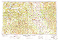
~ West Point MS topo map, 1:250000 scale, 1 X 2 Degree, Historical, 1953, updated 1978
West Point, Mississippi, USGS topographic map dated 1953.
Includes geographic coordinates (latitude and longitude). This topographic map is suitable for hiking, camping, and exploring, or framing it as a wall map.
Printed on-demand using high resolution imagery, on heavy weight and acid free paper, or alternatively on a variety of synthetic materials.
Topos available on paper, Waterproof, Poly, or Tyvek. Usually shipping rolled, unless combined with other folded maps in one order.
- Product Number: USGS-5599126
- Free digital map download (high-resolution, GeoPDF): West Point, Mississippi (file size: 21 MB)
- Map Size: please refer to the dimensions of the GeoPDF map above
- Weight (paper map): ca. 55 grams
- Map Type: POD USGS Topographic Map
- Map Series: HTMC
- Map Verison: Historical
- Cell ID: 69095
- Scan ID: 337284
- Imprint Year: 1978
- Woodland Tint: Yes
- Aerial Photo Year: 1952
- Edit Year: 1970
- Field Check Year: 1953
- Datum: Unstated
- Map Projection: Transverse Mercator
- Map published by: Military, Other
- Map Language: English
- Scanner Resolution: 600 dpi
- Map Cell Name: West Point
- Grid size: 1 X 2 Degree
- Date on map: 1953
- Map Scale: 1:250000
- Geographical region: Mississippi, United States
Neighboring Maps:
All neighboring USGS topo maps are available for sale online at a variety of scales.
Spatial coverage:
Topo map West Point, Mississippi, covers the geographical area associated the following places:
- Carson Ridge (historical) - Hohenlinden - Bowles (historical) - Montevista - Bridgeville - McLeod - Bowies Chapel - Dean Acres - Allgoods Mill (historical) - Minerva - Abbott - Aubrey - Singleton (historical) - Colonial Acres - College Vista - Tollison - Heritage Colony - Hamilton - Grenada - Congress (historical) - Pleasant Ridge (historical) - Rosebloom - Chins Springs (historical) - Beasley - Owens - Fernbank - West - Foltz - Thorn - Bew Springs - Brookwood Estates - Whispering Pines - New Wren - Beeks (historical) - Parkdale - Coal Fire - Nashdale - Triplets Corners - Kilmichael - Magnolia Heights - Deposit (historical) - Gore Springs - Stewart - Tie Plant - Mashulaville - Susie - Big Creek - Bells - Colonial Hills - Westville - Stansel - Pleasant Acres - Beasley - Wellborn Subdivision - North Union (historical) - Hollis - Hill Street Subdivision - Macedonia - Temperence Hill (historical) - Kirkman Landing - Pine Springs - Liberty Hill (historical) - Ellis Subdivision - Grady - McIntyre (historical) - Rodgers (historical) - Wood Manor - Alva - Coles Subdivision - New York (historical) - Sipsey Fork - Quail Valley - Hoffman - Choctaw - Multona Springs - Castalian Springs - Bristo (historical) - Becker - Cherokee Heights - Spring Valley - Remunda Estates - Self Creek - East Aberdeen - Calvary - Parkersburg - McAdams - University Estates - Bluff Springs (historical) - Beatty - Sherwood Forest - Randalls Bluff (historical) - Beards Mill - Pilgrims Rest (historical) - Academy Park - Sykes (historical) - Cedar Point - Mercer (historical) - Sherwood Forest - Flynn (historical) - Clayton Village
- Map Area ID: AREA3433-90-88
- Northwest corner Lat/Long code: USGSNW34-90
- Northeast corner Lat/Long code: USGSNE34-88
- Southwest corner Lat/Long code: USGSSW33-90
- Southeast corner Lat/Long code: USGSSE33-88
- Northern map edge Latitude: 34
- Southern map edge Latitude: 33
- Western map edge Longitude: -90
- Eastern map edge Longitude: -88


