
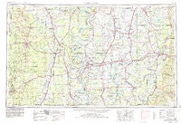
~ Greenwood MS topo map, 1:250000 scale, 1 X 2 Degree, Historical, 1953, updated 1980
Greenwood, Mississippi, USGS topographic map dated 1953.
Includes geographic coordinates (latitude and longitude). This topographic map is suitable for hiking, camping, and exploring, or framing it as a wall map.
Printed on-demand using high resolution imagery, on heavy weight and acid free paper, or alternatively on a variety of synthetic materials.
Topos available on paper, Waterproof, Poly, or Tyvek. Usually shipping rolled, unless combined with other folded maps in one order.
- Product Number: USGS-5599060
- Free digital map download (high-resolution, GeoPDF): Greenwood, Mississippi (file size: 18 MB)
- Map Size: please refer to the dimensions of the GeoPDF map above
- Weight (paper map): ca. 55 grams
- Map Type: POD USGS Topographic Map
- Map Series: HTMC
- Map Verison: Historical
- Cell ID: 68809
- Scan ID: 337256
- Imprint Year: 1980
- Woodland Tint: Yes
- Aerial Photo Year: 1978
- Edit Year: 1979
- Field Check Year: 1953
- Datum: NAD27
- Map Projection: Transverse Mercator
- Map published by: Military, Other
- Map Language: English
- Scanner Resolution: 600 dpi
- Map Cell Name: Greenwood
- Grid size: 1 X 2 Degree
- Date on map: 1953
- Map Scale: 1:250000
- Geographical region: Mississippi, United States
Neighboring Maps:
All neighboring USGS topo maps are available for sale online at a variety of scales.
Spatial coverage:
Topo map Greenwood, Mississippi, covers the geographical area associated the following places:
- McMillan Corner - Dwiggins - Killin - Rose Hill - Duce - Cominto - Tamburo (historical) - Muskedine - Glendora - Kelso - Albritton (historical) - Brushy (historical) - Shaw - Brighton - Bowles - Milo - Cornerville - Crenfree - Somerville - Eastland - Turner - Forrest City (historical) - Boydell - Marcella - Montrose - Long - Gould - Jerome - Wildwood - Nelia (historical) - Shackleford - Sixteenth Section - James - Cascilla - Cosgrove - Minter City - Lacey - Schlater - Matoka (historical) - Quay (historical) - Vickland - Lake Washington (historical) - Linsey (historical) - Niblett Landing - Helm - Hollyknowe - Lamont - Inverness - Seven Pines - Oswego - Pollock (historical) - Belzoni - Parchman - College Heights - Manhattan - Pentecost - Franklin - Mikoma - Watson - Crigler - Skene - Green Hill - Point Comfort - Gill - Symonds - Mileston - Waltonia (historical) - Harwood - Mehr - Tippo - Montgomery - Flautt - Eminence - Blue Lake - Old Dominion - Swan Lake - Priscilla - South Crossett - Avalon - Baxter - Port Anderson (historical) - Webb - Eulogy - Dulweber - Wade (historical) - Pugh - Indianola - Mayday - Deovolente - Meltonia - Black Bayou - Shraderville - Roseneath - Cletonia - Busey - Merigold - Wayside - Richland - Tribbett - Lakehall
- Map Area ID: AREA3433-92-90
- Northwest corner Lat/Long code: USGSNW34-92
- Northeast corner Lat/Long code: USGSNE34-90
- Southwest corner Lat/Long code: USGSSW33-92
- Southeast corner Lat/Long code: USGSSE33-90
- Northern map edge Latitude: 34
- Southern map edge Latitude: 33
- Western map edge Longitude: -92
- Eastern map edge Longitude: -90


