
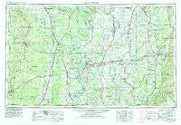
~ Greenwood MS topo map, 1:250000 scale, 1 X 2 Degree, Historical, 1953, updated 1986
Greenwood, Mississippi, USGS topographic map dated 1953.
Includes geographic coordinates (latitude and longitude). This topographic map is suitable for hiking, camping, and exploring, or framing it as a wall map.
Printed on-demand using high resolution imagery, on heavy weight and acid free paper, or alternatively on a variety of synthetic materials.
Topos available on paper, Waterproof, Poly, or Tyvek. Usually shipping rolled, unless combined with other folded maps in one order.
- Product Number: USGS-5599050
- Free digital map download (high-resolution, GeoPDF): Greenwood, Mississippi (file size: 18 MB)
- Map Size: please refer to the dimensions of the GeoPDF map above
- Weight (paper map): ca. 55 grams
- Map Type: POD USGS Topographic Map
- Map Series: HTMC
- Map Verison: Historical
- Cell ID: 68809
- Scan ID: 337251
- Imprint Year: 1986
- Woodland Tint: Yes
- Aerial Photo Year: 1978
- Edit Year: 1979
- Field Check Year: 1953
- Datum: NAD27
- Map Projection: Transverse Mercator
- Map published by United States Geological Survey
- Map Language: English
- Scanner Resolution: 600 dpi
- Map Cell Name: Greenwood
- Grid size: 1 X 2 Degree
- Date on map: 1953
- Map Scale: 1:250000
- Geographical region: Mississippi, United States
Neighboring Maps:
All neighboring USGS topo maps are available for sale online at a variety of scales.
Spatial coverage:
Topo map Greenwood, Mississippi, covers the geographical area associated the following places:
- Hollandale - Rock Springs - Woodside - Chatham - Valewood - Marcella - Lehrton (historical) - Cremer - Gill - Renova - Plantersville - Pinchback - Rough and Ready (historical) - Osotouy (historical) - Grand Lake - Sidon - South Crossett - Reedville - Gum Grove - Decker (historical) - Milroy - Mitchellville - Longwood - Paradise (historical) - Portland - Meeks - Waxhaw - College Heights - Baltzer - McGinty - Pluto - Whitlow - Drew - Meltonia - Monticello - Rawls - Stonewall - Cascilla - Phelan (historical) - Jade (historical) - Readland - Shackleford - Acona - Lakeport - Black Bayou Junction - Old Piney (historical) - Glendora - Isenberg - Malvina - Good Hope - Keirn - Tippo - Nelia (historical) - Mound City - Roark - Oklahoma - Randolph (historical) - Niblett Landing - Quito - Beulah - Cameta - Leavits (historical) - Cottondale - Bommers - Teoc - Bellaire - Bellewood - Turners Flat - Lloyd - Parsons - Meroney - Bovine - Linn - Arkansas City - Tennessee - Promised Land - Empire - Thebes - Caile - Kimball Lake - Steiner - Crossroad - Todd (historical) - Kelso - Warrenton - Riley - Panther Forest - Sisloff Junction - Belle Prairie - Hudspeth - Philipp - Wright - Tralake - Lodi - Moorhead - Princeton (historical) - Blaine - Rolfe Junction - Pace - Doddsville
- Map Area ID: AREA3433-92-90
- Northwest corner Lat/Long code: USGSNW34-92
- Northeast corner Lat/Long code: USGSNE34-90
- Southwest corner Lat/Long code: USGSSW33-92
- Southeast corner Lat/Long code: USGSSE33-90
- Northern map edge Latitude: 34
- Southern map edge Latitude: 33
- Western map edge Longitude: -92
- Eastern map edge Longitude: -90


