
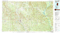
~ Waynesboro MS topo map, 1:100000 scale, 30 X 60 Minute, Historical, 1984, updated 1994
Waynesboro, Mississippi, USGS topographic map dated 1984.
Includes geographic coordinates (latitude and longitude). This topographic map is suitable for hiking, camping, and exploring, or framing it as a wall map.
Printed on-demand using high resolution imagery, on heavy weight and acid free paper, or alternatively on a variety of synthetic materials.
Topos available on paper, Waterproof, Poly, or Tyvek. Usually shipping rolled, unless combined with other folded maps in one order.
- Product Number: USGS-5599038
- Free digital map download (high-resolution, GeoPDF): Waynesboro, Mississippi (file size: 33 MB)
- Map Size: please refer to the dimensions of the GeoPDF map above
- Weight (paper map): ca. 55 grams
- Map Type: POD USGS Topographic Map
- Map Series: HTMC
- Map Verison: Historical
- Cell ID: 68561
- Scan ID: 337243
- Imprint Year: 1994
- Woodland Tint: Yes
- Photo Inspection Year: 1992
- Aerial Photo Year: 1980
- Datum: NAD27
- Map Projection: Universal Transverse Mercator
- Map published by United States Geological Survey
- Map Language: English
- Scanner Resolution: 600 dpi
- Map Cell Name: Waynesboro
- Grid size: 30 X 60 Minute
- Date on map: 1984
- Map Scale: 1:100000
- Geographical region: Mississippi, United States
Neighboring Maps:
All neighboring USGS topo maps are available for sale online at a variety of scales.
Spatial coverage:
Topo map Waynesboro, Mississippi, covers the geographical area associated the following places:
- Sels Prairie - Water Valley - Womack Hill - Loper - Tokio - Wilson - De Soto - Yarbo - Weems (historical) - Barlow - Bolinger - Mill Creek - Slater - Cullomburg - McNeiders (historical) - Coffeeville - Carmichael - Thornton Springs - Fakit Chipunta (historical) - Old Samuel - Paragon - Melvin - Brightwater - Whistler - Threadville - Spring Hill - Hollis Creek - Silver Cross - Clara - Ellisville - Evansboro - Stafford Springs - Jordan - Contwell - Davisville (historical) - Brewer - Chicora - Bashi - Langsdale - Okatuppa - Sumrall - Strengthford - Dunbar - Copeland - Salitpa - Lightsey - Winchester - Center Point - Woods Bluff - Boice - Battles - Needham - Lou - Toxey - Hiwannee - Chapel Hill - Eiler - Robinsons Junction - Barnett - Gretna - Matherville - Dedwylder - Flatwood - Ararat - Belmont - Turner - Vossburg - Denham - Bogueloosa - Buckatunna - Pleasant Hill - Matherville - Hodgewood - Creek (historical) - Barrytown - Rescueville - Gilbertown - Waynesboro - Chappell Hill - Eucutta - Shubuta - Gin (historical) - Saint Stephens - Healing Springs - Nancy - Wimbly - Pineview - Mannassa - Bigbee - Carpenter - Failetown - Mehaffey - Pierces Springs (historical) - Koenton - Aquilla - Shady Grove - Emory - West Bend - Isney - West King
- Map Area ID: AREA3231.5-89-88
- Northwest corner Lat/Long code: USGSNW32-89
- Northeast corner Lat/Long code: USGSNE32-88
- Southwest corner Lat/Long code: USGSSW31.5-89
- Southeast corner Lat/Long code: USGSSE31.5-88
- Northern map edge Latitude: 32
- Southern map edge Latitude: 31.5
- Western map edge Longitude: -89
- Eastern map edge Longitude: -88


