
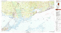
~ Gulfport MS topo map, 1:100000 scale, 30 X 60 Minute, Historical, 1982, updated 1983
Gulfport, Mississippi, USGS topographic map dated 1982.
Includes geographic coordinates (latitude and longitude). This topographic map is suitable for hiking, camping, and exploring, or framing it as a wall map.
Printed on-demand using high resolution imagery, on heavy weight and acid free paper, or alternatively on a variety of synthetic materials.
Topos available on paper, Waterproof, Poly, or Tyvek. Usually shipping rolled, unless combined with other folded maps in one order.
- Product Number: USGS-5598992
- Free digital map download (high-resolution, GeoPDF): Gulfport, Mississippi (file size: 22 MB)
- Map Size: please refer to the dimensions of the GeoPDF map above
- Weight (paper map): ca. 55 grams
- Map Type: POD USGS Topographic Map
- Map Series: HTMC
- Map Verison: Historical
- Cell ID: 67619
- Scan ID: 337213
- Imprint Year: 1983
- Woodland Tint: Yes
- Aerial Photo Year: 1979
- Edit Year: 1982
- Datum: NAD27
- Map Projection: Universal Transverse Mercator
- Map published by United States Geological Survey
- Map Language: English
- Scanner Resolution: 600 dpi
- Map Cell Name: Gulfport
- Grid size: 30 X 60 Minute
- Date on map: 1982
- Map Scale: 1:100000
- Geographical region: Mississippi, United States
Neighboring Maps:
All neighboring USGS topo maps are available for sale online at a variety of scales.
Spatial coverage:
Topo map Gulfport, Mississippi, covers the geographical area associated the following places:
- New Country Club - Oak Harbor - Smallwood Mobile Home Park - Bell Terre Acres - Vidalia Estates Mobile Home Community - Hyde Park - Fenton - Wheel Inn Mobile Home Park - Paradise Park Mobile Home Park - Davis Landing - Gulfside - Bayou Vincent - Saint Joe - Bay Saint Louis - Little Woods - Chef Menteur - Timber Lake Estates - Huntwyck Village - Mississippi City - Magnolia Forest - Santa Rosa - Dolan's Mobile Home Park - Arlington Heights Mobile Home Park - Diamondhead - West Gulfport - Rivercrest - New Hope - Forest Pines - Bayou Paquet Estates - Windsor Place - Michoud - Huntington Estates - Heritage Subdivision - River Oaks - Quail Ridge - Yester Oaks - Eastridge - Ozone Acres - Chamale Cove - Howze Beach - Willow Wood - Cross Gates - Bulah - Bayside Park - Coalville - North Side - Whisperwood Estates - Regal Park Estates - Lacombe - Riverview Addition - Carolyn Park - Cadillac Park - Morgans - Brookwood Estates - Saint Tammany Garden Meadows - Pass Christian - Oak Manor Estates - South Point - Lake Catherine - Westonia (historical) - Dream Courts Mobile Home Park - Salmen - Kings Point - Lake Village - Bonfouca - Colt - Oak Ridge - Ridge Crest Estates Mobile Home Park - Village North - Haaswood - Pettis Mobile Park - Messer's Mobile Manor - Huntington Park - West Hall Park - Spanish Trail Highlands - Waveland - Lake Forest - Pearl River - Forest Glen (historical) - Audubon Place Plaza - Park Place - Avery Estates - Pine Forest - Kathy Mobile Park - Northwood Village - North End - Jones Mill - Parc D'Orleans Number 2 Mobile Home Park - Wimbledon Estates - Slidell Manor - Crossroads Mobile Park - Bayou Bonfouca Estates - De Lisle - Gum Bayou Landing - Abney Country Air - Elysian Acres - Tamaron - Pearl Acres - Flat Top - Poolside Mobile Home Village
- Map Area ID: AREA30.530-90-89
- Northwest corner Lat/Long code: USGSNW30.5-90
- Northeast corner Lat/Long code: USGSNE30.5-89
- Southwest corner Lat/Long code: USGSSW30-90
- Southeast corner Lat/Long code: USGSSE30-89
- Northern map edge Latitude: 30.5
- Southern map edge Latitude: 30
- Western map edge Longitude: -90
- Eastern map edge Longitude: -89


