
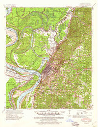
~ Vicksburg MS topo map, 1:62500 scale, 15 X 15 Minute, Historical, 1941, updated 1960
Vicksburg, Mississippi, USGS topographic map dated 1941.
Includes geographic coordinates (latitude and longitude). This topographic map is suitable for hiking, camping, and exploring, or framing it as a wall map.
Printed on-demand using high resolution imagery, on heavy weight and acid free paper, or alternatively on a variety of synthetic materials.
Topos available on paper, Waterproof, Poly, or Tyvek. Usually shipping rolled, unless combined with other folded maps in one order.
- Product Number: USGS-5598894
- Free digital map download (high-resolution, GeoPDF): Vicksburg, Mississippi (file size: 9 MB)
- Map Size: please refer to the dimensions of the GeoPDF map above
- Weight (paper map): ca. 55 grams
- Map Type: POD USGS Topographic Map
- Map Series: HTMC
- Map Verison: Historical
- Cell ID: 64090
- Scan ID: 337157
- Imprint Year: 1960
- Woodland Tint: Yes
- Edit Year: 1942
- Survey Year: 1940
- Datum: NAD
- Map Projection: Polyconic
- Map published by United States Army Corps of Engineers
- Map published by United States Department of War
- Map Language: English
- Scanner Resolution: 600 dpi
- Map Cell Name: Vicksburg
- Grid size: 15 X 15 Minute
- Date on map: 1941
- Map Scale: 1:62500
- Geographical region: Mississippi, United States
Neighboring Maps:
All neighboring USGS topo maps are available for sale online at a variety of scales.
Spatial coverage:
Topo map Vicksburg, Mississippi, covers the geographical area associated the following places:
- Porters Chapel - Beechwood - Southall - Culkin - Valley Mills - Greenbriar - Bernard Acres - Lakewood - Jetts - Rose Hill - Redwood - Bellemeade - Newmans Grove - Woodlawn - Kings - Lake Forest - Long Lake - Jonestown - Delta - Great Lake Estates - Cedars - Openwood Plantation - Vicksburg - Newmans - Blakely - Twin Lake - Waltersville - Villanova - Southhaven - Speeds Addition - Stout - Signal
- Map Area ID: AREA32.532.25-91-90.75
- Northwest corner Lat/Long code: USGSNW32.5-91
- Northeast corner Lat/Long code: USGSNE32.5-90.75
- Southwest corner Lat/Long code: USGSSW32.25-91
- Southeast corner Lat/Long code: USGSSE32.25-90.75
- Northern map edge Latitude: 32.5
- Southern map edge Latitude: 32.25
- Western map edge Longitude: -91
- Eastern map edge Longitude: -90.75


