
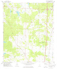
~ Bailey Lake MS topo map, 1:24000 scale, 7.5 X 7.5 Minute, Historical, 1975, updated 1978
Bailey Lake, Mississippi, USGS topographic map dated 1975.
Includes geographic coordinates (latitude and longitude). This topographic map is suitable for hiking, camping, and exploring, or framing it as a wall map.
Printed on-demand using high resolution imagery, on heavy weight and acid free paper, or alternatively on a variety of synthetic materials.
Topos available on paper, Waterproof, Poly, or Tyvek. Usually shipping rolled, unless combined with other folded maps in one order.
- Product Number: USGS-5595276
- Free digital map download (high-resolution, GeoPDF): Bailey Lake, Mississippi (file size: 9 MB)
- Map Size: please refer to the dimensions of the GeoPDF map above
- Weight (paper map): ca. 55 grams
- Map Type: POD USGS Topographic Map
- Map Series: HTMC
- Map Verison: Historical
- Cell ID: 2132
- Scan ID: 335269
- Imprint Year: 1978
- Woodland Tint: Yes
- Aerial Photo Year: 1974
- Field Check Year: 1975
- Datum: NAD27
- Map Projection: Transverse Mercator
- Map published by United States Geological Survey
- Map Language: English
- Scanner Resolution: 600 dpi
- Map Cell Name: Bailey Lake
- Grid size: 7.5 X 7.5 Minute
- Date on map: 1975
- Map Scale: 1:24000
- Geographical region: Mississippi, United States
Neighboring Maps:
All neighboring USGS topo maps are available for sale online at a variety of scales.
Spatial coverage:
Topo map Bailey Lake, Mississippi, covers the geographical area associated the following places:
- Big Sand Creek Watershed Y-32-9b Dam - Supervisor District 4 - Marvin Cemetery - Hazel Green Church - Summerfield Cemetery - Saint Johns Chapel - Pelucia Watershed Y-33a-5 Dam - Nebo Cemetery - Waters Lake - New Salem Cemetery - Powells Creek - Meadows Lake - Acorner Church - Nebo Church - New Salem Church - G H Curtis Lake Dam - Big Sand Watershed Y-32-9a Dam - Bluff Springs Cemetery - Bluff Springs Methodist Church - Friendship Church - Ebenezer Church - Middleton (historical) - Interchange 185 - Summerfield Church - Booths Lake - Bryantville (historical) - Bailey Lake
- Map Area ID: AREA33.533.375-89.875-89.75
- Northwest corner Lat/Long code: USGSNW33.5-89.875
- Northeast corner Lat/Long code: USGSNE33.5-89.75
- Southwest corner Lat/Long code: USGSSW33.375-89.875
- Southeast corner Lat/Long code: USGSSE33.375-89.75
- Northern map edge Latitude: 33.5
- Southern map edge Latitude: 33.375
- Western map edge Longitude: -89.875
- Eastern map edge Longitude: -89.75


