
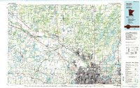
~ Anoka MN topo map, 1:100000 scale, 30 X 60 Minute, Historical, 1985, updated 1985
Anoka, Minnesota, USGS topographic map dated 1985.
Includes geographic coordinates (latitude and longitude). This topographic map is suitable for hiking, camping, and exploring, or framing it as a wall map.
Printed on-demand using high resolution imagery, on heavy weight and acid free paper, or alternatively on a variety of synthetic materials.
Topos available on paper, Waterproof, Poly, or Tyvek. Usually shipping rolled, unless combined with other folded maps in one order.
- Product Number: USGS-5985308
- Free digital map download (high-resolution, GeoPDF): Anoka, Minnesota (file size: 17 MB)
- Map Size: please refer to the dimensions of the GeoPDF map above
- Weight (paper map): ca. 55 grams
- Map Type: POD USGS Topographic Map
- Map Series: HTMC
- Map Verison: Historical
- Cell ID: 67056
- Scan ID: 805556
- Imprint Year: 1985
- Woodland Tint: Yes
- Aerial Photo Year: 1980
- Edit Year: 1985
- Datum: NAD27
- Map Projection: Universal Transverse Mercator
- Planimetric: Yes
- Map published by United States Geological Survey
- Map Language: English
- Scanner Resolution: 508 dpi
- Map Cell Name: Anoka
- Grid size: 30 X 60 Minute
- Date on map: 1985
- Map Scale: 1:100000
- Geographical region: Minnesota, United States
Neighboring Maps:
All neighboring USGS topo maps are available for sale online at a variety of scales.
Spatial coverage:
Topo map Anoka, Minnesota, covers the geographical area associated the following places:
- Nowthen - Lake Netta - Oak Grove - Ham Lake - Berning Mill - White Bear Lake - Weber - Shoreview - Crystal - Lake Sarah - Johnsville - Columbia Heights - Circle Pines - Woodhaven Manufactured Home Community - Big Lake Estates - Itasca Village (historical) - Lino Lakes - Buffalo - Ditter - Gloster - Brooklyn Park - Monticello - Burschville - Ramsey - Hasty - Salida - Arden Hills - Brooklyn Center - Montrose - Hilltop - North Oaks - Kjellbergs Mobile Home Park - Orrock - Blaine - Isanti Estates - West Side Mobile Home Park - Dupont - Champlin - New Brighton - Twelve Hi Mobile Home Estates - Dayton - Vadnais Heights - Martin Lake - Cedar - Anoka - East Bethel - Cardigan Junction - Rogers - Elk River - Clear Lake - Roseville - Independence - Saint Francis - Armstrong - Delano - Centerville - Maple Grove - Saint Michael - Isanti - Montrose Manor Mobile Home Park - Andover - Robbinsdale - Thompson Heights - Hanover - Pulaski Mobile Home Park - Spring Lake Park - Golden Valley - Coon Rapids - Riverbend Mobile Home Park - Little Canada - Mounds View - Lexington - Rockford - Hoffmans Corner - Fletcher - Crown - Otsego - Rassat - Bald Eagle - Linwood - Medina - Buffalo Manor East - Coopers Corner - River Terrace Mobile Home Park - Coon Creek - Coon Lake Beach - Rockford Riverview Estates - Leighton - Big Lake - Silver Creek - Corcoran - Lake Orono Estates - Bufflao Manor - Northdale - Lake Shore Park - Becker - Oak Park - Fridley - Waverly - Osseo
- Map Area ID: AREA45.545-94-93
- Northwest corner Lat/Long code: USGSNW45.5-94
- Northeast corner Lat/Long code: USGSNE45.5-93
- Southwest corner Lat/Long code: USGSSW45-94
- Southeast corner Lat/Long code: USGSSE45-93
- Northern map edge Latitude: 45.5
- Southern map edge Latitude: 45
- Western map edge Longitude: -94
- Eastern map edge Longitude: -93


