
~ Albert Lea MN topo map, 1:100000 scale, 30 X 60 Minute, Historical, 1985, updated 1985
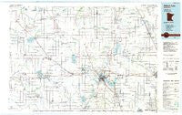
Albert Lea, Minnesota, USGS topographic map dated 1985.
Includes geographic coordinates (latitude and longitude). This topographic map is suitable for hiking, camping, and exploring, or framing it as a wall map.
Printed on-demand using high resolution imagery, on heavy weight and acid free paper, or alternatively on a variety of synthetic materials.
Topos available on paper, Waterproof, Poly, or Tyvek. Usually shipping rolled, unless combined with other folded maps in one order.
- Product Number: USGS-5985204
- Free digital map download (high-resolution, GeoPDF): Albert Lea, Minnesota (file size: 11 MB)
- Map Size: please refer to the dimensions of the GeoPDF map above
- Weight (paper map): ca. 55 grams
- Map Type: POD USGS Topographic Map
- Map Series: HTMC
- Map Verison: Historical
- Cell ID: 67025
- Scan ID: 805549
- Imprint Year: 1985
- Woodland Tint: Yes
- Aerial Photo Year: 1980
- Edit Year: 1985
- Datum: NAD27
- Map Projection: Universal Transverse Mercator
- Planimetric: Yes
- Map published by United States Geological Survey
- Map Language: English
- Scanner Resolution: 508 dpi
- Map Cell Name: Albert Lea
- Grid size: 30 X 60 Minute
- Date on map: 1985
- Map Scale: 1:100000
- Geographical region: Minnesota, United States
Neighboring Maps:
All neighboring USGS topo maps are available for sale online at a variety of scales.
Spatial coverage:
Topo map Albert Lea, Minnesota, covers the geographical area associated the following places:
- Rainbow Terrace Mobile Home Park - Litomysl - Bricelyn - Bass Mobile Home Park - Mapleton - Steele Center - Moscow - Alden - Minnesota Lake - Baroda - Murtaugh - Bancroft - Easton - Emmons Trailer Court - Bath - Dell - South Hollandale - Emmons - Blooming Prairie - Twin Grove - Union - Armstrong - Lemond - Conger - Myrtle - Brush Creek - Albert Lea - Sigsbee - Muckland - Lerdal - Walters - Austin Acres - Oakland - Waldorf - Mansfield - Hollandale - Gordonsville - Maple Island - Stoney Creek Estates - Ziemer's Mobile Home Park - Geneva - New Richland - Hillcrest Mobile Home Park - Lakeview Mobile Home Park - Corning - Kiester - London - Petran - Glenville - Hollandale Junction - Freeborn - Manchester - Twin Lakes - Hartland - Boening Mobile Home Park - Frost - Summit - Otisco - Hope - Ellendale - Vista - Bixby - Matawan - Prime Village of Wells Mobile Home Park - Hayward - Wells - Clarks Grove - River Point
- Map Area ID: AREA4443.5-94-93
- Northwest corner Lat/Long code: USGSNW44-94
- Northeast corner Lat/Long code: USGSNE44-93
- Southwest corner Lat/Long code: USGSSW43.5-94
- Southeast corner Lat/Long code: USGSSE43.5-93
- Northern map edge Latitude: 44
- Southern map edge Latitude: 43.5
- Western map edge Longitude: -94
- Eastern map edge Longitude: -93


