
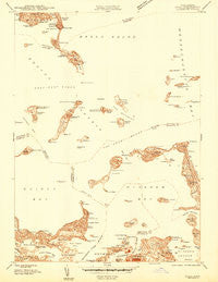
~ Hull MA topo map, 1:24000 scale, 7.5 X 7.5 Minute, Historical, 1944
Hull, Massachusetts, USGS topographic map dated 1944.
Includes geographic coordinates (latitude and longitude). This topographic map is suitable for hiking, camping, and exploring, or framing it as a wall map.
Printed on-demand using high resolution imagery, on heavy weight and acid free paper, or alternatively on a variety of synthetic materials.
Topos available on paper, Waterproof, Poly, or Tyvek. Usually shipping rolled, unless combined with other folded maps in one order.
- Product Number: USGS-5647919
- Free digital map download (high-resolution, GeoPDF): Hull, Massachusetts (file size: 7 MB)
- Map Size: please refer to the dimensions of the GeoPDF map above
- Weight (paper map): ca. 55 grams
- Map Type: POD USGS Topographic Map
- Map Series: HTMC
- Map Verison: Historical
- Cell ID: 21423
- Scan ID: 350216
- Datum: NAD27
- Map Projection: Polyconic
- Advance: Yes
- Preliminary map: Yes
- Map published by United States Geological Survey
- Keywords: Nonstandard Press Run
- Map Language: English
- Scanner Resolution: 600 dpi
- Map Cell Name: Hull
- Grid size: 7.5 X 7.5 Minute
- Date on map: 1944
- Map Scale: 1:24000
- Geographical region: Massachusetts, United States
Neighboring Maps:
All neighboring USGS topo maps are available for sale online at a variety of scales.
Spatial coverage:
Topo map Hull, Massachusetts, covers the geographical area associated the following places:
- Adams Shore - Fort Warren - Crow Point - Point Shirley - Stony Beach - Houghs Neck - Waveland - Rock Island - Cottage Hill - Fort Duvall - Windemere - Fort Andrews - Pemberton - Hull - Germantown - Bayside - Allerton - Fort Revere - Fort Dawes - Post Island - Cottage Park - Court Park - Merrymount
- Map Area ID: AREA42.37542.25-71-70.875
- Northwest corner Lat/Long code: USGSNW42.375-71
- Northeast corner Lat/Long code: USGSNE42.375-70.875
- Southwest corner Lat/Long code: USGSSW42.25-71
- Southeast corner Lat/Long code: USGSSE42.25-70.875
- Northern map edge Latitude: 42.375
- Southern map edge Latitude: 42.25
- Western map edge Longitude: -71
- Eastern map edge Longitude: -70.875


