
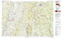
~ Pittsfield MA topo map, 1:100000 scale, 30 X 60 Minute, Historical, 1986, updated 1993
Pittsfield, Massachusetts, USGS topographic map dated 1986.
Includes geographic coordinates (latitude and longitude). This topographic map is suitable for hiking, camping, and exploring, or framing it as a wall map.
Printed on-demand using high resolution imagery, on heavy weight and acid free paper, or alternatively on a variety of synthetic materials.
Topos available on paper, Waterproof, Poly, or Tyvek. Usually shipping rolled, unless combined with other folded maps in one order.
- Product Number: USGS-5636107
- Free digital map download (high-resolution, GeoPDF): Pittsfield, Massachusetts (file size: 32 MB)
- Map Size: please refer to the dimensions of the GeoPDF map above
- Weight (paper map): ca. 55 grams
- Map Type: POD USGS Topographic Map
- Map Series: HTMC
- Map Verison: Historical
- Cell ID: 72650
- Scan ID: 353177
- Imprint Year: 1993
- Woodland Tint: Yes
- Photo Inspection Year: 1989
- Aerial Photo Year: 1978
- Edit Year: 1986
- Datum: NAD27
- Map Projection: Universal Transverse Mercator
- Map published by United States Geological Survey
- Map Language: English
- Scanner Resolution: 600 dpi
- Map Cell Name: Pittsfield
- Grid size: 30 X 60 Minute
- Date on map: 1986
- Map Scale: 1:100000
- Geographical region: Massachusetts, United States
Neighboring Maps:
All neighboring USGS topo maps are available for sale online at a variety of scales.
Spatial coverage:
Topo map Pittsfield, Massachusetts, covers the geographical area associated the following places:
- Brick Tavern - Dalton - Crane Lake Camp - Saxton - Limestreet - Whitehouse Crossing - Oakdale - Ashley Falls - Flatbrook - Copake - Ancramdale - Surprise - Canaan - Gallatinville - Humphreysville - Coeymans Hollow - Snyderville - Niverville - Sodom - Riders Mills - Chatham Center - West Otis - College Park - Golden Acres - Interlaken - Green River - Oak Hill Landing - Brainard - West Taghkanic - Dormansville - Blue Store - Katsbaan - Adams Junction - North Egremont - Richmond Furnace - Dwarf Orchard Park - Glenco Mills - New Lebanon - Pontoosuc - Kinderhook - Quarryville - Alford - South Lee - New Baltimore - Camp Chimney Corners - East Chatham - Malden Bridge - Pulvers - Bingham Mills - Linlithgo - Wheatleigh - North Chatham - Mahkeenac Shores - Rossman - Camp Sumner - Lenox Dale - Jutkosky Court - Spencertown - Place Corners - Hollowville - Otis - Arnolds Mill - Camp Stevenson - Lenox Station - Moorhouse Corner - Carey Corner - Monterey - Malden-on-Hudson - Washington - Mill River - Ghent - Stones Mobile Manor - Middlefield - Lee - Red Mills - Mount Marion Park - Bonny Rigg Corners - West Lebanon - North Hillsdale - Canoe Hill - Clayton - Indian Fields (historical) - Red Hook Mills - Clermont - Hansons Mobile Home Park - Earlton - Kerleys Corners - Hartsville - Kiskaton Mobile Home Park - Otis Wood Lanes - Southfield - Churchtown - Camp Russell - Cairo Junction - Lebanon Springs - Camp Wyoma - Camp Lenore - Smith Landing - New Concord - East Hillsdale
- Map Area ID: AREA42.542-74-73
- Northwest corner Lat/Long code: USGSNW42.5-74
- Northeast corner Lat/Long code: USGSNE42.5-73
- Southwest corner Lat/Long code: USGSSW42-74
- Southeast corner Lat/Long code: USGSSE42-73
- Northern map edge Latitude: 42.5
- Southern map edge Latitude: 42
- Western map edge Longitude: -74
- Eastern map edge Longitude: -73


