
~ Lowell MA topo map, 1:100000 scale, 30 X 60 Minute, Historical, 1984, updated 1984
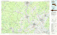
Lowell, Massachusetts, USGS topographic map dated 1984.
Includes geographic coordinates (latitude and longitude). This topographic map is suitable for hiking, camping, and exploring, or framing it as a wall map.
Printed on-demand using high resolution imagery, on heavy weight and acid free paper, or alternatively on a variety of synthetic materials.
Topos available on paper, Waterproof, Poly, or Tyvek. Usually shipping rolled, unless combined with other folded maps in one order.
- Product Number: USGS-5636095
- Free digital map download (high-resolution, GeoPDF): Lowell, Massachusetts (file size: 27 MB)
- Map Size: please refer to the dimensions of the GeoPDF map above
- Weight (paper map): ca. 55 grams
- Map Type: POD USGS Topographic Map
- Map Series: HTMC
- Map Verison: Historical
- Cell ID: 67876
- Scan ID: 353167
- Imprint Year: 1984
- Woodland Tint: Yes
- Aerial Photo Year: 1978
- Edit Year: 1984
- Datum: NAD27
- Map Projection: Universal Transverse Mercator
- Planimetric: Yes
- Map published by United States Geological Survey
- Map Language: English
- Scanner Resolution: 600 dpi
- Map Cell Name: Lowell
- Grid size: 30 X 60 Minute
- Date on map: 1984
- Map Scale: 1:100000
- Geographical region: Massachusetts, United States
Neighboring Maps:
All neighboring USGS topo maps are available for sale online at a variety of scales.
Spatial coverage:
Topo map Lowell, Massachusetts, covers the geographical area associated the following places:
- Sargent Corners - Waites Corner - South Merrimack - Mishawum - Windham - Carlisle - Riverside - Rocks Village - Rogersville (historical) - Cowbell Corners - Chases Grove - Ayer - Canobie Lake - Derry - Westminster - Chester - Tozier Corner - The Pines - North Woburn - Gibson Four Corners - New Ipswich - Grosvenor Corner - Andover - Woodland Park - Lyndeborough - Reading Highlands - New Boston - Camp Collier - East Rindge - Meadow Wood Trailer Park - New Ipswich Center - Boxford Station - Pingryville - Centre Village (historical) - Noyes Terrace - East Parish - Sandown - Nashua - Rowes Corner - West Groton - South Danville - Silver Lake - Ward Hill - West Townsend - Wamesit - Meadowbrook Acres Mobile Home Park - Goodrichville - West Wilton - South Middleton - Camp Nashoba - West Kingston - Greenville - Bleachery - Bakers Grove - South Brookline - West Leominster - Newton Junction - Vose - Mountain Base - Bedford - Davisville - Pine Grove Park - Fremont Station - Cluffs Crossing - Wellville - South Ashburnham - Hovey Corner - South Kingston - Salem - Dunstable - River Pines - Mason - Woodsville - Lunenburg Station - High Bridge - South Pepperell - Lunenburg - Ward Corner - North Andover - Shirley Center - Smithville - North Chelmsford - Ballardvale - Wachusett Station - North Billerica - Forge Village - Methuen - Kingston - Mont Vernon - North Ashburnham - Belvidere - North Pepperell - Hayward Corner - East Groton - Marble Ridge Station - Camp Massapoag - Maple Park - Richardson (historical) - Havenville - Village of Nagog Woods
- Map Area ID: AREA4342.5-72-71
- Northwest corner Lat/Long code: USGSNW43-72
- Northeast corner Lat/Long code: USGSNE43-71
- Southwest corner Lat/Long code: USGSSW42.5-72
- Southeast corner Lat/Long code: USGSSE42.5-71
- Northern map edge Latitude: 43
- Southern map edge Latitude: 42.5
- Western map edge Longitude: -72
- Eastern map edge Longitude: -71


