
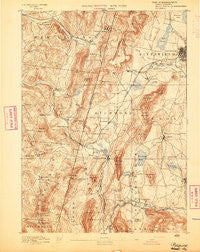
~ Pittsfield MA topo map, 1:62500 scale, 15 X 15 Minute, Historical, 1893
Pittsfield, Massachusetts, USGS topographic map dated 1893.
Includes geographic coordinates (latitude and longitude). This topographic map is suitable for hiking, camping, and exploring, or framing it as a wall map.
Printed on-demand using high resolution imagery, on heavy weight and acid free paper, or alternatively on a variety of synthetic materials.
Topos available on paper, Waterproof, Poly, or Tyvek. Usually shipping rolled, unless combined with other folded maps in one order.
- Product Number: USGS-5635785
- Free digital map download (high-resolution, GeoPDF): Pittsfield, Massachusetts (file size: 10 MB)
- Map Size: please refer to the dimensions of the GeoPDF map above
- Weight (paper map): ca. 55 grams
- Map Type: POD USGS Topographic Map
- Map Series: HTMC
- Map Verison: Historical
- Cell ID: 61040
- Scan ID: 352935
- Survey Year: 1888
- Datum: Unstated
- Map Projection: Unstated
- Map published by United States Geological Survey
- Map Language: English
- Scanner Resolution: 600 dpi
- Map Cell Name: Pittsfield
- Grid size: 15 X 15 Minute
- Date on map: 1893
- Map Scale: 1:62500
- Geographical region: Massachusetts, United States
Neighboring Maps:
All neighboring USGS topo maps are available for sale online at a variety of scales.
Spatial coverage:
Topo map Pittsfield, Massachusetts, covers the geographical area associated the following places:
- New Lebanon Center - Camp Witawentin - Camp Marion White - Camp Russell - Crane Lake Camp - Barkerville - Larrywaug - Stockbridge - West Pittsfield - Canaan - Hancock Shaker Village - Queechy - Richmond - Stearnsville - West Stockbridge - New Britain (historical) - Stevens Corner - Interlaken - Green River - Glendale - Eastover - Camp Kingsmont - Adams Crossing Mobile Home Park - Housatonic - Camp Mah-Kee-Nac - Flatbrook - Wheatleigh - South Lee - Tanglewood - Carey Corner - Lenox - Beachwood - State Line - Austerlitz - West Stockbridge Center - Mahkeenac Heights - Lebanon Springs - Richmond Furnace - Rockdale Mills - Mahkeenac Shores - Camp Stevenson - Hansons Mobile Home Park - Williamsville - Canaan Center - Mahkeenac Terrace - West Lebanon - New Lebanon
- Map Area ID: AREA42.542.25-73.5-73.25
- Northwest corner Lat/Long code: USGSNW42.5-73.5
- Northeast corner Lat/Long code: USGSNE42.5-73.25
- Southwest corner Lat/Long code: USGSSW42.25-73.5
- Southeast corner Lat/Long code: USGSSE42.25-73.25
- Northern map edge Latitude: 42.5
- Southern map edge Latitude: 42.25
- Western map edge Longitude: -73.5
- Eastern map edge Longitude: -73.25


