
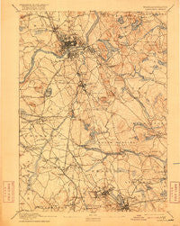
~ Lawrence MA topo map, 1:62500 scale, 15 X 15 Minute, Historical, 1893, updated 1916
Lawrence, Massachusetts, USGS topographic map dated 1893.
Includes geographic coordinates (latitude and longitude). This topographic map is suitable for hiking, camping, and exploring, or framing it as a wall map.
Printed on-demand using high resolution imagery, on heavy weight and acid free paper, or alternatively on a variety of synthetic materials.
Topos available on paper, Waterproof, Poly, or Tyvek. Usually shipping rolled, unless combined with other folded maps in one order.
- Product Number: USGS-5635607
- Free digital map download (high-resolution, GeoPDF): Lawrence, Massachusetts (file size: 8 MB)
- Map Size: please refer to the dimensions of the GeoPDF map above
- Weight (paper map): ca. 55 grams
- Map Type: POD USGS Topographic Map
- Map Series: HTMC
- Map Verison: Historical
- Cell ID: 56592
- Scan ID: 352797
- Imprint Year: 1916
- Survey Year: 1886
- Datum: Unstated
- Map Projection: Unstated
- Map published by United States Geological Survey
- Map Language: English
- Scanner Resolution: 600 dpi
- Map Cell Name: Lawrence
- Grid size: 15 X 15 Minute
- Date on map: 1893
- Map Scale: 1:62500
- Geographical region: Massachusetts, United States
Neighboring Maps:
All neighboring USGS topo maps are available for sale online at a variety of scales.
Spatial coverage:
Topo map Lawrence, Massachusetts, covers the geographical area associated the following places:
- Tewksbury - Reading Highlands - Haggetts - Fox Hill - South Lynnfield - Ballardvale - North Tewksbury - Mishawum - North Andover Center - South Lawrence - South Wilmington - Shawsheen Village - North Reading - Brigadoon Village - Burlington - Lowell Junction - Marsh Corner - West Andover - Stevens Crossing - Wakefield - Wilmington Junction - Wilmington - West Parish - Lynnfield - Marble Ridge Station - East Billerica - West Boxford - Lawrence - The Pines - Pinehurst - North Andover - Burtts Crossing - North Woburn - Suttons Mills - West Village - East Parish - Andover - Pattenville - South Middleton - Reading - Montrose - Hampshire Road - Havenville - North Wilmington - South Groveland - Middleton - Mount Vernon Park - Boxford Station - Shawsheen Heights - Tewksbury Junction - Silver Lake - Methuen - Marston Corners
- Map Area ID: AREA42.7542.5-71.25-71
- Northwest corner Lat/Long code: USGSNW42.75-71.25
- Northeast corner Lat/Long code: USGSNE42.75-71
- Southwest corner Lat/Long code: USGSSW42.5-71.25
- Southeast corner Lat/Long code: USGSSE42.5-71
- Northern map edge Latitude: 42.75
- Southern map edge Latitude: 42.5
- Western map edge Longitude: -71.25
- Eastern map edge Longitude: -71


