
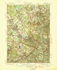
~ Lexington MA topo map, 1:31680 scale, 7.5 X 7.5 Minute, Historical, 1946
Lexington, Massachusetts, USGS topographic map dated 1946.
Includes geographic coordinates (latitude and longitude). This topographic map is suitable for hiking, camping, and exploring, or framing it as a wall map.
Printed on-demand using high resolution imagery, on heavy weight and acid free paper, or alternatively on a variety of synthetic materials.
Topos available on paper, Waterproof, Poly, or Tyvek. Usually shipping rolled, unless combined with other folded maps in one order.
- Product Number: USGS-5634401
- Free digital map download (high-resolution, GeoPDF): Lexington, Massachusetts (file size: 11 MB)
- Map Size: please refer to the dimensions of the GeoPDF map above
- Weight (paper map): ca. 55 grams
- Map Type: POD USGS Topographic Map
- Map Series: HTMC
- Map Verison: Historical
- Cell ID: 25590
- Scan ID: 351838
- Woodland Tint: Yes
- Visual Version Number: 2
- Survey Year: 1943
- Datum: NAD27
- Map Projection: Polyconic
- Map published by United States Geological Survey
- Map Language: English
- Scanner Resolution: 600 dpi
- Map Cell Name: Lexington
- Grid size: 7.5 X 7.5 Minute
- Date on map: 1946
- Map Scale: 1:31680
- Geographical region: Massachusetts, United States
Neighboring Maps:
All neighboring USGS topo maps are available for sale online at a variety of scales.
Spatial coverage:
Topo map Lexington, Massachusetts, covers the geographical area associated the following places:
- Shaker Glen - West Medford - Winnmere - Belmont - Waltham - Waverley - Arlington - Clematis Brook Station - Payson Park - Camp Cabot - Beaver Brook Station - East Arlington - Cummingsville - Larchwood - Piety Corner - Medford Hillside - Sutherland Woods - Cedar Hill Camp - Eastview Park - Woods Corner - Camp Ted - East Lexington - Wedgemere - Arlington Heights - Woburn - Strawberry Hill - Winchester Highlands - Kingston - Mount Auburn - Shakerhill - Lakeview - Waltham Highlands - Winchester - North Cambridge - Lexington - Follen Heights - Symmes Corner - Walnut Hill - Brattle - North Lexington - Central Square - Huron Village - Fuller Heights - Munroe Station - Countryside - Woburn Highlands
- Map Area ID: AREA42.542.375-71.25-71.125
- Northwest corner Lat/Long code: USGSNW42.5-71.25
- Northeast corner Lat/Long code: USGSNE42.5-71.125
- Southwest corner Lat/Long code: USGSSW42.375-71.25
- Southeast corner Lat/Long code: USGSSE42.375-71.125
- Northern map edge Latitude: 42.5
- Southern map edge Latitude: 42.375
- Western map edge Longitude: -71.25
- Eastern map edge Longitude: -71.125


