
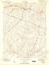
~ Woodbine MD topo map, 1:24000 scale, 7.5 X 7.5 Minute, Historical, 1950
Woodbine, Maryland, USGS topographic map dated 1950.
Includes geographic coordinates (latitude and longitude). This topographic map is suitable for hiking, camping, and exploring, or framing it as a wall map.
Printed on-demand using high resolution imagery, on heavy weight and acid free paper, or alternatively on a variety of synthetic materials.
Topos available on paper, Waterproof, Poly, or Tyvek. Usually shipping rolled, unless combined with other folded maps in one order.
- Product Number: USGS-5930651
- Free digital map download (high-resolution, GeoPDF): Woodbine, Maryland (file size: 10 MB)
- Map Size: please refer to the dimensions of the GeoPDF map above
- Weight (paper map): ca. 55 grams
- Map Type: POD USGS Topographic Map
- Map Series: HTMC
- Map Verison: Historical
- Cell ID: 49735
- Scan ID: 461524
- Aerial Photo Year: 1945
- Field Check Year: 1945
- Datum: NAD27
- Map Projection: Polyconic
- Map published by United States Geological Survey
- Map published by United States Army Corps of Engineers
- Map Language: English
- Scanner Resolution: 600 dpi
- Map Cell Name: Woodbine
- Grid size: 7.5 X 7.5 Minute
- Date on map: 1950
- Map Scale: 1:24000
- Geographical region: Maryland, United States
Neighboring Maps:
All neighboring USGS topo maps are available for sale online at a variety of scales.
Spatial coverage:
Topo map Woodbine, Maryland, covers the geographical area associated the following places:
- The Heritage - Warfield Estates - Twin Maples - Cabin River Farms - Roxbury - Florence - Rover Mill Estates - Nursery View - Red Lion Inn Estates - Countryside - Lisbon - Carrs Mill - Rainbow Estates - Glenwood Estates - Flag Marsh Heights - Florence Manor - Gary - Hoods Mill - Lisbon Meadows - Daisy Meadows - Gwenlee Estates - Justifiable - Lisbon Manor - Green Meadows - Daisy - New Port - Hipsleys Mill - Cooksville - Brantly - River Plantations - Inwood - Dill - Woodbine - Vicky Estates - Ritz Estates - Millys Delight - Woodside Estates - Patapsco Overlook - Poplar Springs - Bushy Park Estates - Jennings Chapel Woods - Highview Estates - Daisy Woods - Mill Green - Daisy Hill Estates - Jaycox - Timberleigh Village - Morgan - Villa Monticello - Florence Farms - Knollwood - Kabik Korner - River Farms - Glenwood - Lisbon Acres - Roxbury Mills - Eyre View - Watersville
- Map Area ID: AREA39.37539.25-77.125-77
- Northwest corner Lat/Long code: USGSNW39.375-77.125
- Northeast corner Lat/Long code: USGSNE39.375-77
- Southwest corner Lat/Long code: USGSSW39.25-77.125
- Southeast corner Lat/Long code: USGSSE39.25-77
- Northern map edge Latitude: 39.375
- Southern map edge Latitude: 39.25
- Western map edge Longitude: -77.125
- Eastern map edge Longitude: -77


