
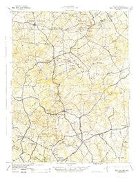
~ Bel Air MD topo map, 1:62500 scale, 15 X 15 Minute, Historical, 1942
Bel Air, Maryland, USGS topographic map dated 1942.
Includes geographic coordinates (latitude and longitude). This topographic map is suitable for hiking, camping, and exploring, or framing it as a wall map.
Printed on-demand using high resolution imagery, on heavy weight and acid free paper, or alternatively on a variety of synthetic materials.
Topos available on paper, Waterproof, Poly, or Tyvek. Usually shipping rolled, unless combined with other folded maps in one order.
- Product Number: USGS-5930247
- Free digital map download (high-resolution, GeoPDF): Bel Air, Maryland (file size: 8 MB)
- Map Size: please refer to the dimensions of the GeoPDF map above
- Weight (paper map): ca. 55 grams
- Map Type: POD USGS Topographic Map
- Map Series: HTMC
- Map Verison: Historical
- Cell ID: 51118
- Scan ID: 461367
- Woodland Tint: Yes
- Aerial Photo Year: 1940
- Datum: NAD27
- Map Projection: Polyconic
- Map published by United States Army Corps of Engineers
- Map published by United States Department of War
- Map Language: English
- Scanner Resolution: 600 dpi
- Map Cell Name: Belair
- Grid size: 15 X 15 Minute
- Date on map: 1942
- Map Scale: 1:62500
- Geographical region: Maryland, United States
Neighboring Maps:
All neighboring USGS topo maps are available for sale online at a variety of scales.
Spatial coverage:
Topo map Bel Air, Maryland, covers the geographical area associated the following places:
- North Harford Heights - Woodridge Manor - Camelot - Rutledge - Fairway - Greenfields - Meadow Springs - Country Club Park - Homestead Village - Hickory - Belle Meade - Poplar Grove - Colonial Acres - Northridge - Eagle View - Hickory Village Mobile Home Park - Fountain Green Heights - Rockridge Forest - Worthington Heights - Delta - Hill-N-Dale - Spooners Creek - Bay Ridge - Stoneleigh - Gibson Manor - Kings Charter - Bel Forest - Furnace - Sharon Acres - Springdale - Hemlock Ridge - Street - Harford Hills - Viking Highlands - Mechanicsville (historical) - The Pond - Willwood - Jarrettsville - Magness - Scenic View - Martindale - Saint Anne - West Riding - Harford Ranchettes - Creswell - Brierwood - Longmeadow - Warwick - Round Acres - Hickory Hills - Fallsmont - Fountain Green Estates - Bakersfield - Michaels Corner - Ailston - Howard Park - Woodsbrook - Leew Woods - Green Ridge - Village Manor - Harford Estates - Hazelwood - Roland Heights - Deer Park - Moxley Acres - Country Village - South Bel Air - Bynum - Mill Stone Estates - Allibone (historical) - Moorland - Laurel Brook - Advocate Hill Farms - Coffman - Campus Hill Farms - Cherby-Maurlyn Estates - Quiet Inheritance - Hoerr - Pine Crest - Powder Mill Addition - Minefield - Graceton - Bryansville - Hy-Crest - Upper Crossroads - Harford Downs - Vale - Shawnee - Cedarwood - Fountain Glen - Gunpowder Farms - Ferncliff - Putnam Hill - Rock Spring - Glenwood Garth - Scots Fancy - Scarboro - Greenbrier Hills - Bright Oaks - Eden Hills
- Map Area ID: AREA39.7539.5-76.5-76.25
- Northwest corner Lat/Long code: USGSNW39.75-76.5
- Northeast corner Lat/Long code: USGSNE39.75-76.25
- Southwest corner Lat/Long code: USGSSW39.5-76.5
- Southeast corner Lat/Long code: USGSSE39.5-76.25
- Northern map edge Latitude: 39.75
- Southern map edge Latitude: 39.5
- Western map edge Longitude: -76.5
- Eastern map edge Longitude: -76.25


