
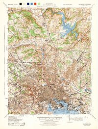
~ Baltimore MD topo map, 1:62500 scale, 15 X 15 Minute, Historical, 1944
Baltimore, Maryland, USGS topographic map dated 1944.
Includes geographic coordinates (latitude and longitude). This topographic map is suitable for hiking, camping, and exploring, or framing it as a wall map.
Printed on-demand using high resolution imagery, on heavy weight and acid free paper, or alternatively on a variety of synthetic materials.
Topos available on paper, Waterproof, Poly, or Tyvek. Usually shipping rolled, unless combined with other folded maps in one order.
- Product Number: USGS-5930233
- Free digital map download (high-resolution, GeoPDF): Baltimore, Maryland (file size: 11 MB)
- Map Size: please refer to the dimensions of the GeoPDF map above
- Weight (paper map): ca. 55 grams
- Map Type: POD USGS Topographic Map
- Map Series: HTMC
- Map Verison: Historical
- Cell ID: 50921
- Scan ID: 461354
- Woodland Tint: Yes
- Datum: NAD27
- Map Projection: Polyconic
- Map published by United States Geological Survey
- Map published by United States Army Corps of Engineers
- Map published by United States Army
- Map published by United States Department of War
- Map Language: English
- Scanner Resolution: 600 dpi
- Map Cell Name: Baltimore
- Grid size: 15 X 15 Minute
- Date on map: 1944
- Map Scale: 1:62500
- Geographical region: Maryland, United States
Neighboring Maps:
All neighboring USGS topo maps are available for sale online at a variety of scales.
Spatial coverage:
Topo map Baltimore, Maryland, covers the geographical area associated the following places:
- Morrell Park - Stanbrook - Garrison Farms - Hunt Cup Hill - Worthington Ridge - Northwind Village - Eudowood - Cub Hill - Goodnow Hill - Wakefield - Fishtown - Anneslie - Latrobe Homes - Brookview Farms - Ridge Grove - Colgate - Beacon Hill - Claremont (historical) - The Lakes - Guilford - Eden Roc - Summit Park - Westport - Violetville - Powhatan Hill - Harford Farms - Mount Royal - Riverview (historical) - Brooklandwood Estates - Rockland Run - Eastpoint - Fallswood - Arlington - Villa Cresta - Holland Hills - Brooklandville - Helmsley Court - Frederick Douglass Homes - Sherwood Hills - Putty Hill - Orchard Hills - Riderwood Hills - Talbotts Choice - Westview Park - Bosley (historical) - Parkside Heights - Joppa Heights - Summer Hill - Cherry Hill - Dun Rovin - Shawan Valley - Cedarwood Estates - Howardsville - Cub Hills - Valley North - West Arlington - Windsor Mill Manor - The Village - Valley Stream - Pineleigh - Mount Washington - Armistead Homes - Pinehurst - Cambria - Powhatan - Chestnut Ridge - Riderwood - Dulaney Hills - Fellowship Forest - Hunting Lodge - Fallstaff - Chapel Hill - Windemere - Bare Hills - Five Springs West - Lakeside - Glenside Park - Beverly Hills - Shoresville (historical) - Carroll - High Point - Hillsdale Green - Green Ridge - Villa Nova - Walbrook - Notch Cliff - Harford Hills - Goucher Woods - Valley Crest - Hillstead - Calverton Heights - Gallagher Park - Deer Run - Havenwood - Ridgemont - Bluegrass Heights - Milestone Manor - Catonsville Heights - Hudson Heights - Ranchleigh
- Map Area ID: AREA39.539.25-76.75-76.5
- Northwest corner Lat/Long code: USGSNW39.5-76.75
- Northeast corner Lat/Long code: USGSNE39.5-76.5
- Southwest corner Lat/Long code: USGSSW39.25-76.75
- Southeast corner Lat/Long code: USGSSE39.25-76.5
- Northern map edge Latitude: 39.5
- Southern map edge Latitude: 39.25
- Western map edge Longitude: -76.75
- Eastern map edge Longitude: -76.5


