
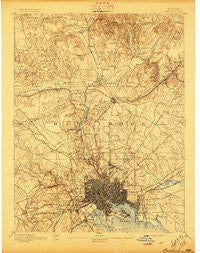
~ Baltimore MD topo map, 1:62500 scale, 15 X 15 Minute, Historical, 1894, updated 1897
Baltimore, Maryland, USGS topographic map dated 1894.
Includes geographic coordinates (latitude and longitude). This topographic map is suitable for hiking, camping, and exploring, or framing it as a wall map.
Printed on-demand using high resolution imagery, on heavy weight and acid free paper, or alternatively on a variety of synthetic materials.
Topos available on paper, Waterproof, Poly, or Tyvek. Usually shipping rolled, unless combined with other folded maps in one order.
- Product Number: USGS-5930231
- Free digital map download (high-resolution, GeoPDF): Baltimore, Maryland (file size: 9 MB)
- Map Size: please refer to the dimensions of the GeoPDF map above
- Weight (paper map): ca. 55 grams
- Map Type: POD USGS Topographic Map
- Map Series: HTMC
- Map Verison: Historical
- Cell ID: 50921
- Scan ID: 461353
- Imprint Year: 1897
- Survey Year: 1890
- Datum: Unstated
- Map Projection: Unstated
- Map published by United States Geological Survey
- Map Language: English
- Scanner Resolution: 600 dpi
- Map Cell Name: Baltimore
- Grid size: 15 X 15 Minute
- Date on map: 1894
- Map Scale: 1:62500
- Geographical region: Maryland, United States
Neighboring Maps:
All neighboring USGS topo maps are available for sale online at a variety of scales.
Spatial coverage:
Topo map Baltimore, Maryland, covers the geographical area associated the following places:
- Villa Nova - Parktowne - Belmar - Anthonyville - Dulaney Village - Fells Point - Dogwood Hills - Briarwood Farms - Timonium Heights - Pikesville - Timonium - Mount Vernon - Harristown - Bloomsbury - Harford Farms - Pennbrook - Woodhome Heights - Mays Chapel Village - Harrington Manor - Yorktown - Four Winds - Havenwood - Hillendale Farms - Carroll Manor - Glenmont - Green Ridge - Hunters Hill - Rockland - Defense Heights - Evergreen - Cheswolde - Thornleigh - West Forest Park - High Point - Holly Knoll Estates - Rutherford Green - Dixon Hill - Morrell Park - Ashland - Elmwood - Westport - The Falls - Warren - Perring Village - Woodberry - Hillsdale Green - Hunt Cup Hill - Glenmar - Bridleshire - The Willows of Ruxton - Guilford - Huntspring - Arlington - Stratford - Parkville Heights - Brookwood - Cherry Hill - Haver Hill - Worthington Ridge - Beaumont Park - Pickwick - Catonsville Manor - Goucher Woods - Cub Hill - Deer Run - Cronhardt - Armagh - Fellowship Forest - Dundalk - Patapsco Woods - Knollcrest Farms - Harborview - Laurelford - Valley View - Eudowood - Paradise - Liberty Mobile Home Park - Morgan Park - Marlywood - Chapelgate - Sugarvale Estates - Beacon Hill - Eastfield - Dickeyville - Britinay Hills - Idlewood - Wetheredsville - Cedarcroft - Talbotts Choice - Mount Winans - Rosedale - Lakeland - Mount Hope - Valley North - Willow Glen - Melvale - Ridgeleigh - Howard Park - Village of Vanderway - Donnybrook
- Map Area ID: AREA39.539.25-76.75-76.5
- Northwest corner Lat/Long code: USGSNW39.5-76.75
- Northeast corner Lat/Long code: USGSNE39.5-76.5
- Southwest corner Lat/Long code: USGSSW39.25-76.75
- Southeast corner Lat/Long code: USGSSE39.25-76.5
- Northern map edge Latitude: 39.5
- Southern map edge Latitude: 39.25
- Western map edge Longitude: -76.75
- Eastern map edge Longitude: -76.5


