
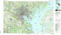
~ Baltimore MD topo map, 1:100000 scale, 30 X 60 Minute, Historical, 1984, updated 1984
Baltimore, Maryland, USGS topographic map dated 1984.
Includes geographic coordinates (latitude and longitude). This topographic map is suitable for hiking, camping, and exploring, or framing it as a wall map.
Printed on-demand using high resolution imagery, on heavy weight and acid free paper, or alternatively on a variety of synthetic materials.
Topos available on paper, Waterproof, Poly, or Tyvek. Usually shipping rolled, unless combined with other folded maps in one order.
- Product Number: USGS-5368624
- Free digital map download (high-resolution, GeoPDF): Baltimore, Maryland (file size: 36 MB)
- Map Size: please refer to the dimensions of the GeoPDF map above
- Weight (paper map): ca. 55 grams
- Map Type: POD USGS Topographic Map
- Map Series: HTMC
- Map Verison: Historical
- Cell ID: 67093
- Scan ID: 257704
- Imprint Year: 1984
- Woodland Tint: Yes
- Aerial Photo Year: 1982
- Edit Year: 1984
- Datum: NAD27
- Map Projection: Universal Transverse Mercator
- Map published by United States Geological Survey
- Map Language: English
- Scanner Resolution: 600 dpi
- Map Cell Name: Baltimore
- Grid size: 30 X 60 Minute
- Date on map: 1984
- Map Scale: 1:100000
- Geographical region: Maryland, United States
Neighboring Maps:
All neighboring USGS topo maps are available for sale online at a variety of scales.
Spatial coverage:
Topo map Baltimore, Maryland, covers the geographical area associated the following places:
- Green Springs Hills - Brookfield on the Magothy - Freetown Village - Riverview (historical) - Obretch Estates - White Marsh Station - Anneslie - Silvergate East - Clear Water Beach - Caveswood - Sewells Orchard - Sweetser Heights - Slacks Corner - Fallstaff - Gwynnbrook - Silver Woods - Normandy Woods - Chestnut Farms - Oak Forest - Seven Oaks - Walbrook - Morrisville - Hampton Gardens - North Shore - Becks Landing - Silver Spring Station - Edesville - Shirley Estates - Joyce - River Park Estates - Irongate - Glenside Park - Cliftonbrook - Glen Brook - Armistead Homes - Pettebone Farms - Browns Woods Villa - Apple Ridge - Flohrville - Waterloo - Gerber Knoll - Brooklyn - Oakview - Harford Furnace - Chartridge - Gill Estates - Constant Friendship - Oxford Green - Anthonyville - Charlestown - Summerfield - Arundel View - Good Hope Estates - Briarwood Farms - Mountain Wood - Highland Lake - Halethorpe - Dulaney Village - Evergreen Park - Orangeville - Patapsco Woods - Bulle Rock - Hidden Hills - Ferguson Meadows - Woodbridge Valley - Brittany - Benson - Elkridge - Shawan - Twin Ridge - Folly Farms - Sunnyfield Estates - Brierwood - Eagles Loft - Delmont - Winans (historical) - Oak Hollow - Academy Lane - Rugby Hall - Carroll - Everlea - Manor Oaks - Fox Pause - Margate - Rodgers Forge - Germantown - Carney - Chesmar - Washington Park - Lakewood - Velvet Ridge - Catonsville Manor - Westchester - Village of Painters Mill - Pine Hill - Perry Hall Estates - Arnold - Sherwood - Bird Hill Estates - Penwood Mobile Home Park
- Map Area ID: AREA39.539-77-76
- Northwest corner Lat/Long code: USGSNW39.5-77
- Northeast corner Lat/Long code: USGSNE39.5-76
- Southwest corner Lat/Long code: USGSSW39-77
- Southeast corner Lat/Long code: USGSSE39-76
- Northern map edge Latitude: 39.5
- Southern map edge Latitude: 39
- Western map edge Longitude: -77
- Eastern map edge Longitude: -76


