
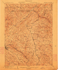
~ Westminster MD topo map, 1:62500 scale, 15 X 15 Minute, Historical, 1905, updated 1911
Westminster, Maryland, USGS topographic map dated 1905.
Includes geographic coordinates (latitude and longitude). This topographic map is suitable for hiking, camping, and exploring, or framing it as a wall map.
Printed on-demand using high resolution imagery, on heavy weight and acid free paper, or alternatively on a variety of synthetic materials.
Topos available on paper, Waterproof, Poly, or Tyvek. Usually shipping rolled, unless combined with other folded maps in one order.
- Product Number: USGS-5368584
- Free digital map download (high-resolution, GeoPDF): Westminster, Maryland (file size: 10 MB)
- Map Size: please refer to the dimensions of the GeoPDF map above
- Weight (paper map): ca. 55 grams
- Map Type: POD USGS Topographic Map
- Map Series: HTMC
- Map Verison: Historical
- Cell ID: 64434
- Scan ID: 257690
- Imprint Year: 1911
- Survey Year: 1903
- Datum: Unstated
- Map Projection: Unstated
- Map published by United States Geological Survey
- Map Language: English
- Scanner Resolution: 600 dpi
- Map Cell Name: Westminster
- Grid size: 15 X 15 Minute
- Date on map: 1905
- Map Scale: 1:62500
- Geographical region: Maryland, United States
Neighboring Maps:
All neighboring USGS topo maps are available for sale online at a variety of scales.
Spatial coverage:
Topo map Westminster, Maryland, covers the geographical area associated the following places:
- Brunetto Acres - Harris Heights - Raven Run - Armacost - Evergreen Hills - Topkapi - Steeplechase - Fairmount North - Stiltz - Gross Mill Estates - Finlandia - Pine Knoll - Sylvan Park - Southglenn Farms - Berrywood Village - Walnut Grove Mills - Sterner Heights Estates - Advocates Choice - Reeds Village - Bixler - North Carroll Farms - Valley View - Castles Rising - Shirley Manor - Carroll Meadows - Wolf Hill - Hoffmanville - Mikules Manor - Cascade Estates - Brothers Delight - Gunpowder Ridge - Bachman Valley Estates - Clydesdale Acres - Rarjem Acres - Carroll County Trails - Roller - Greenmount - Whitehouse - Grand Valley Acres - Castle Oaks - Cape Horn South - Harrington - Richwynn Hill - Wil-Mar Acres - Blue Grass Manor - Royal Heights - Hidden Valley - Winsome Heights - Maple Grove - Oakdale Manor - Buckingham View - Alma Meadows - Chazdale North - Pineridge Farms - Lees Mill - Deep Run - Hokes - Trenton Mill - Lismarelu Farms - Autumn Ridge - Trebee Highlands - Laura Lee Estates - Mason Dixon Estates - Blackrock - Clear View - Glasers Hill - Fairfield - Hunt Ridge - Upperco - Rockdale - Hideaway Estates - Cape Hill Farms - Foreston Ridge Estates - Rockbrook Village - Middle Brooke - Saint Pauls - Wine Bel Valley - Village of Peachwood - Summer Hills - Alto Vista - Wesley Chapel - Dover - Reese - Cranberry - Benedict Woods - Breezy Hill Estates - Walnut Ridge - Tara Oaks - Rolling Falls Estates - Spring Meadow - Green Acres - Constance Acres - Hollinsland - Lawndale Acres - Cedarbrook - Southwood - Monarch Meadow - Houcksville - Shawnee View - Snydersburg Manor
- Map Area ID: AREA39.7539.5-77-76.75
- Northwest corner Lat/Long code: USGSNW39.75-77
- Northeast corner Lat/Long code: USGSNE39.75-76.75
- Southwest corner Lat/Long code: USGSSW39.5-77
- Southeast corner Lat/Long code: USGSSE39.5-76.75
- Northern map edge Latitude: 39.75
- Southern map edge Latitude: 39.5
- Western map edge Longitude: -77
- Eastern map edge Longitude: -76.75


