
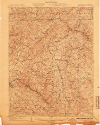
~ Westminster MD topo map, 1:62500 scale, 15 X 15 Minute, Historical, 1905
Westminster, Maryland, USGS topographic map dated 1905.
Includes geographic coordinates (latitude and longitude). This topographic map is suitable for hiking, camping, and exploring, or framing it as a wall map.
Printed on-demand using high resolution imagery, on heavy weight and acid free paper, or alternatively on a variety of synthetic materials.
Topos available on paper, Waterproof, Poly, or Tyvek. Usually shipping rolled, unless combined with other folded maps in one order.
- Product Number: USGS-5368582
- Free digital map download (high-resolution, GeoPDF): Westminster, Maryland (file size: 11 MB)
- Map Size: please refer to the dimensions of the GeoPDF map above
- Weight (paper map): ca. 55 grams
- Map Type: POD USGS Topographic Map
- Map Series: HTMC
- Map Verison: Historical
- Cell ID: 64434
- Scan ID: 257689
- Survey Year: 1903
- Datum: Unstated
- Map Projection: Unstated
- Map published by United States Geological Survey
- Map Language: English
- Scanner Resolution: 600 dpi
- Map Cell Name: Westminster
- Grid size: 15 X 15 Minute
- Date on map: 1905
- Map Scale: 1:62500
- Geographical region: Maryland, United States
Neighboring Maps:
All neighboring USGS topo maps are available for sale online at a variety of scales.
Spatial coverage:
Topo map Westminster, Maryland, covers the geographical area associated the following places:
- Brunetto Acres - Monarch Meadow - Aspen Run - Lees Corner - Boring - Carrs Store (historical) - Hokes - Chazdale North - Park Ridge - Lawndale Acres - Valley Vista North - Snydersburg - Young Mans Fancy - Mikules Manor - Velvet Run - New Mexico - Finlandia - Grand Valley Acres - Gunpowder Acres - Smallwood Acres - Pineridge Farms - Laura Lee Estates - Kempfield - Autumn Ridge - Maple Grove - Sandyville - Dug Hill - Smithtown Ridge - Ebbvale Estates - Patapsco Woods - Maple View - Snydersburg Manor - Roller - Singer Heights - Brummel - Ross Run Estates - Blackrock - White Oak Ridge - Village of Bachman - Carroll Meadows - Fiscal - Bixler Valley Estates - Winsome Heights - Steeplechase - Tabbys Delight - Rebecca Ridge - Walnut Ridge - Duncans Hill - Bixler - Webers Ridge - Southwood - Brilhart Terrace - Mexico - Bollinger Estates - Dove Ridge - Smallwood - Dublin Manor - Glover Acres - Wolf Hill - Shirley Manor - Alesia Heights - Vangline Acres - England Estates - Rockdale - Haletown - Alma Meadows - Hoffmans Mill - Harris Heights - Lismarelu Farms - Bethel - Woodensburg - Harrington - Washington Court - Wil-Mar Acres - Dominos Acres - Ben-Har Heights - Forest Knoll - Roberts Field - Rebas Retreat - Hampstead - Greenmount - Eastview - Shiloh - Campus Heights - Prettyboy Trails - Hillandale Trailer Park - Meadow View - Whispering Valley - Bethel Ridge - Happy Valley - Oakleigh Ridge - Richwynn Hill - Hampstead Heights - Pleasant Grove - Greenbrier - Westminster - Highfield Estates - Walkers Run - Sylvan Park - Green Acres
- Map Area ID: AREA39.7539.5-77-76.75
- Northwest corner Lat/Long code: USGSNW39.75-77
- Northeast corner Lat/Long code: USGSNE39.75-76.75
- Southwest corner Lat/Long code: USGSSW39.5-77
- Southeast corner Lat/Long code: USGSSE39.5-76.75
- Northern map edge Latitude: 39.75
- Southern map edge Latitude: 39.5
- Western map edge Longitude: -77
- Eastern map edge Longitude: -76.75


