
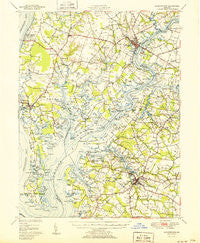
~ Chestertown MD topo map, 1:62500 scale, 15 X 15 Minute, Historical, 1951
Chestertown, Maryland, USGS topographic map dated 1951.
Includes geographic coordinates (latitude and longitude). This topographic map is suitable for hiking, camping, and exploring, or framing it as a wall map.
Printed on-demand using high resolution imagery, on heavy weight and acid free paper, or alternatively on a variety of synthetic materials.
Topos available on paper, Waterproof, Poly, or Tyvek. Usually shipping rolled, unless combined with other folded maps in one order.
- Product Number: USGS-5368028
- Free digital map download (high-resolution, GeoPDF): Chestertown, Maryland (file size: 7 MB)
- Map Size: please refer to the dimensions of the GeoPDF map above
- Weight (paper map): ca. 55 grams
- Map Type: POD USGS Topographic Map
- Map Series: HTMC
- Map Verison: Historical
- Cell ID: 52481
- Scan ID: 257340
- Woodland Tint: Yes
- Aerial Photo Year: 1947
- Field Check Year: 1948
- Datum: NAD27
- Map Projection: Polyconic
- Map published by United States Geological Survey
- Map published by United States Army Corps of Engineers
- Map Language: English
- Scanner Resolution: 600 dpi
- Map Cell Name: Chestertown
- Grid size: 15 X 15 Minute
- Date on map: 1951
- Map Scale: 1:62500
- Geographical region: Maryland, United States
Neighboring Maps:
All neighboring USGS topo maps are available for sale online at a variety of scales.
Spatial coverage:
Topo map Chestertown, Maryland, covers the geographical area associated the following places:
- Bulle Rock - Tolchester - Pomona - Starkey Corner - Fannells Meadow - The Grove - Burrisville - Orchard View - Crosby - Hickory Thicket - Shipyard Landing - Primrose Garth - Coventry Farms - Kings Town Manor - Blakeford - Old Town - Reba L Anthony Estates - Heron Point - Crestview - Becks Landing - Lees Corner - Rock Hall - Harrisburg (historical) - Centreville - Mile Tree Village - River Estates - Georgetown - White Banks - Edesville - Deerfield - Langford Bay Estates - Cliffs City - Kennersley - Wilmers - Langford - Sparks Corner - Baywood Manor - Denbigh (historical) - Corsica Landing - Woods Edge - Calvert Heights - Overton - Chester Harbor - Earle Landing - Langford Acres - Kings Court - Piney Grove - Reeses Corner - Washington Park - New Yarmouth - Baker - McCleans Corner - Orchard Hill - Carville - River Edge - Kingstown - McKinleyville - Browns Corner - Conquest Beach - Pear Tree Point - Kent Acres - Tolchester Heights - Corsica Landing Estates - Tolchester Beach - Kimberly Park - Sandy Bottom - Pioneer Point Farms - Hidden Acres - Delta Heights - Brownsville - Pusey Landing - Morganec Village - Ashland Landing - Recovery - Amberly Trailer Park - Queen Annes Circle - Quaker Neck Landing - Chestertown - Riverview - Fairlee - Earles Branch - Tolchester Estates - Johnsontown - Sharpstown - Heather Heights - Centreville Landing - Rolphs - Goose Hollow - Tilghmans Terrace - Chesmar - Remington Farms - Southeast Landing - Royston Shores - Woodstream - Catlin (historical) - Indian Town - Mallard Point - Foxley Manor - Hunters Ridge - Tall Timbers Estates
- Map Area ID: AREA39.2539-76.25-76
- Northwest corner Lat/Long code: USGSNW39.25-76.25
- Northeast corner Lat/Long code: USGSNE39.25-76
- Southwest corner Lat/Long code: USGSSW39-76.25
- Southeast corner Lat/Long code: USGSSE39-76
- Northern map edge Latitude: 39.25
- Southern map edge Latitude: 39
- Western map edge Longitude: -76.25
- Eastern map edge Longitude: -76


