
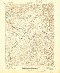
~ Brandywine MD topo map, 1:62500 scale, 15 X 15 Minute, Historical, 1913, updated 1946
Brandywine, Maryland, USGS topographic map dated 1913.
Includes geographic coordinates (latitude and longitude). This topographic map is suitable for hiking, camping, and exploring, or framing it as a wall map.
Printed on-demand using high resolution imagery, on heavy weight and acid free paper, or alternatively on a variety of synthetic materials.
Topos available on paper, Waterproof, Poly, or Tyvek. Usually shipping rolled, unless combined with other folded maps in one order.
- Product Number: USGS-5368000
- Free digital map download (high-resolution, GeoPDF): Brandywine, Maryland (file size: 8 MB)
- Map Size: please refer to the dimensions of the GeoPDF map above
- Weight (paper map): ca. 55 grams
- Map Type: POD USGS Topographic Map
- Map Series: HTMC
- Map Verison: Historical
- Cell ID: 51736
- Scan ID: 257326
- Imprint Year: 1946
- Survey Year: 1911
- Datum: Unstated
- Map Projection: Polyconic
- Map published by United States Geological Survey
- Map Language: English
- Scanner Resolution: 600 dpi
- Map Cell Name: Brandywine
- Grid size: 15 X 15 Minute
- Date on map: 1913
- Map Scale: 1:62500
- Geographical region: Maryland, United States
Neighboring Maps:
All neighboring USGS topo maps are available for sale online at a variety of scales.
Spatial coverage:
Topo map Brandywine, Maryland, covers the geographical area associated the following places:
- Woodridge Acres - Lakeside Mews - Gwynn Park - Glen Oak - Lynnbrook - Mattawoman - Land Tree - Springhaven Woods - Zekiah Valley - Ashford - Jomar Acres - Hunt Club Estates - Carrico Mill Estates - Piscataway Hills - Wellington Woods - Old Colony - Townshend - The Meadows - Bowen Estates - White Hall Terrace - Holly Station - Delight - Gallant Acres - Independence Village - Brice - Clinton Hills - Fort Washington Forest - Forest Estates - Ridgeview - Old Ford Hills - Warrlinda - Early Manor - Holt Manor - White Plains Village - Deerwood - Beantown - Bel Air Acres - Accokeek Acres - Pine Grove Estates - Sylvanhurst - Ashbox - Forest Grove - Duley - Bryantown Estates - Fort Foote Estates - Breezy Knolls - Holly Hill - Forest Glen Estates - Acton Village - Tippett - Weestwood Estates - Treeview Estates - Piscataway Estates - Gallant Green Woods - Holly Tree Park - Spring Oak Estates - Maxwelton - Hughesville Manor - Meadow Creek Manor - Rolee Estates - Greenmont - Dorchester - Masons - Chapel Hill - Cheltenham - Spring Valley - Bolton - Plainview Gardens - Saint Charles - Jennie Run Estates - White Plains Mobile Home Park - Marbella - Valley View - Brandywine - Haldane - Hunters Ridge - Warburton Oaks - Carrington - Cedarville - Newtown - Idlewood Park - Westlake Village - Boniwood - Hillwood - T B - Cedarville Mobile Home Park - Baden - Sharperville - Brookwood Acres - Three Brothers - Pinefield - South Piscataway - Huntington - Karen Knolls - Mount Carmel Woods - Cleveland Park Estates - Gillespie Mobile Home Court - Cedar Lawn - Park Estates - Talbert (historical)
- Map Area ID: AREA38.7538.5-77-76.75
- Northwest corner Lat/Long code: USGSNW38.75-77
- Northeast corner Lat/Long code: USGSNE38.75-76.75
- Southwest corner Lat/Long code: USGSSW38.5-77
- Southeast corner Lat/Long code: USGSSE38.5-76.75
- Northern map edge Latitude: 38.75
- Southern map edge Latitude: 38.5
- Western map edge Longitude: -77
- Eastern map edge Longitude: -76.75


