
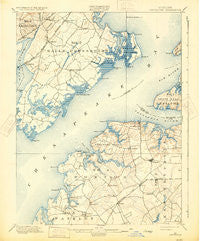
~ Betterton MD topo map, 1:62500 scale, 15 X 15 Minute, Historical, 1900, updated 1931
Betterton, Maryland, USGS topographic map dated 1900.
Includes geographic coordinates (latitude and longitude). This topographic map is suitable for hiking, camping, and exploring, or framing it as a wall map.
Printed on-demand using high resolution imagery, on heavy weight and acid free paper, or alternatively on a variety of synthetic materials.
Topos available on paper, Waterproof, Poly, or Tyvek. Usually shipping rolled, unless combined with other folded maps in one order.
- Product Number: USGS-5367976
- Free digital map download (high-resolution, GeoPDF): Betterton, Maryland (file size: 7 MB)
- Map Size: please refer to the dimensions of the GeoPDF map above
- Weight (paper map): ca. 55 grams
- Map Type: POD USGS Topographic Map
- Map Series: HTMC
- Map Verison: Historical
- Cell ID: 51291
- Scan ID: 257314
- Imprint Year: 1931
- Survey Year: 1899
- Datum: Unstated
- Map Projection: Polyconic
- Map published by United States Geological Survey
- Map Language: English
- Scanner Resolution: 600 dpi
- Map Cell Name: Betterton
- Grid size: 15 X 15 Minute
- Date on map: 1900
- Map Scale: 1:62500
- Geographical region: Maryland, United States
Neighboring Maps:
All neighboring USGS topo maps are available for sale online at a variety of scales.
Spatial coverage:
Topo map Betterton, Maryland, covers the geographical area associated the following places:
- Chelsea - Chesapeake Landing - Millbrook - Hanesville - Buck Neck - Forest Greens - Michaelsville - Worton Heights - Still Pond - Buck Neck Landing - Runnymeade Estates - Great Oak Estates - Coleman - Melitota - Hassengers Corner - Urieville - Goose Hill - Wrights Trailer Village - Bigwoods - Kinnairds Point - Robinson Corner - Smithville - Riverside - Great Oak Landing - Morgnec - Kentfield - Copeland - Wrights Mobile Home Village - Lynch - Perryman - Newtown - Hepbron - Perrywood - Henley Park - Riverside Village of Church Creek - Old Baltimore - Echo Hill - Catts Corner - Betterton - Chesapeake Haven - Great Oak Manor - Cole (historical) - Parson Hill - Bush River Mobile Home Park - Cheshaven - Worton - Hazelmoor - Bush River - The Pines - Butlertown - Belcamp - Bayside Village - Ripkins Corner - Wildwood - Worton Manor Mobile Home Park
- Map Area ID: AREA39.539.25-76.25-76
- Northwest corner Lat/Long code: USGSNW39.5-76.25
- Northeast corner Lat/Long code: USGSNE39.5-76
- Southwest corner Lat/Long code: USGSSW39.25-76.25
- Southeast corner Lat/Long code: USGSSE39.25-76
- Northern map edge Latitude: 39.5
- Southern map edge Latitude: 39.25
- Western map edge Longitude: -76.25
- Eastern map edge Longitude: -76


