
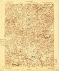
~ Belair MD topo map, 1:62500 scale, 15 X 15 Minute, Historical, 1901, updated 1922
Belair, Maryland, USGS topographic map dated 1901.
Includes geographic coordinates (latitude and longitude). This topographic map is suitable for hiking, camping, and exploring, or framing it as a wall map.
Printed on-demand using high resolution imagery, on heavy weight and acid free paper, or alternatively on a variety of synthetic materials.
Topos available on paper, Waterproof, Poly, or Tyvek. Usually shipping rolled, unless combined with other folded maps in one order.
- Product Number: USGS-5367966
- Free digital map download (high-resolution, GeoPDF): Belair, Maryland (file size: 11 MB)
- Map Size: please refer to the dimensions of the GeoPDF map above
- Weight (paper map): ca. 55 grams
- Map Type: POD USGS Topographic Map
- Map Series: HTMC
- Map Verison: Historical
- Cell ID: 51118
- Scan ID: 257309
- Imprint Year: 1922
- Survey Year: 1900
- Datum: Unstated
- Map Projection: Unstated
- Map published by United States Geological Survey
- Map Language: English
- Scanner Resolution: 600 dpi
- Map Cell Name: Belair
- Grid size: 15 X 15 Minute
- Date on map: 1901
- Map Scale: 1:62500
- Geographical region: Maryland, United States
Neighboring Maps:
All neighboring USGS topo maps are available for sale online at a variety of scales.
Spatial coverage:
Topo map Belair, Maryland, covers the geographical area associated the following places:
- Moores Mill - Locust Knoll - Coopstown - Eagle View - Jarrettswood - Worthington Heights - Todd Lakes - Montford Glen - Hickory Hills - White Oak - Brierwood - Longmeadow - Willwood - Seven Cedars - Fountain Green - Knollwood - Vale Hills - Shamrock - Willows - Green Ridge - Rock Acres - Priestford Hills - Highland Ridge - Fallston - Harold Heights - Old Dixie Manor - Jarrettsville - Chestnut Hill - Spring House Estates - Coldstream - North Harford Heights - Greendale Estates - Fairway - Roland Heights - Fairwind Farms - Lyns Rest - Melrose - Slate Hill - Dublin Manor - Upper Crossroads - Deerfield - Fairmont - Quiet Inheritance - Roland Place - Winters Run - Maryland Ponderosa - Pinehurst - Parkshire - Oak Ridge - Parliament Ridge - Woodfield - Spooners Creek - Fairview - Timberlea - Frogtown - Cooper - Martindale - Wakefield Meadows - Viking Highlands - Fountain Glen - North Bel Air - Cherry Hill - Grafton Heights - Advocate Hill Farms - Laurel Brook - Harlan Square - Klein - Camelot - Rockdale Manor - Putnam View Estates - Bradford Village - Tudor Manor - Fairwood Heights - Glenwood Garth - Marywood - Meadowlark Estates - Foxborough Farms - Coffman - Wellington Woods - Gibson Manor - Deerhaven - Bramblewood - Federal Hill Heights - Kalmia - Prospect - Drexel - Bakersfield - Powder Mill Addition - Fawn Grove - Harford Hunt Manor - Stirrup Run - Fallsmont - Moxley Acres - Bel Air Acres - Pine Crest - Bellvale - Hy-Crest - Woodside - Clear Spring Estates - Howard Park
- Map Area ID: AREA39.7539.5-76.5-76.25
- Northwest corner Lat/Long code: USGSNW39.75-76.5
- Northeast corner Lat/Long code: USGSNE39.75-76.25
- Southwest corner Lat/Long code: USGSSW39.5-76.5
- Southeast corner Lat/Long code: USGSSE39.5-76.25
- Northern map edge Latitude: 39.75
- Southern map edge Latitude: 39.5
- Western map edge Longitude: -76.5
- Eastern map edge Longitude: -76.25


