
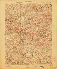
~ Belair MD topo map, 1:62500 scale, 15 X 15 Minute, Historical, 1901, updated 1913
Belair, Maryland, USGS topographic map dated 1901.
Includes geographic coordinates (latitude and longitude). This topographic map is suitable for hiking, camping, and exploring, or framing it as a wall map.
Printed on-demand using high resolution imagery, on heavy weight and acid free paper, or alternatively on a variety of synthetic materials.
Topos available on paper, Waterproof, Poly, or Tyvek. Usually shipping rolled, unless combined with other folded maps in one order.
- Product Number: USGS-5367964
- Free digital map download (high-resolution, GeoPDF): Belair, Maryland (file size: 11 MB)
- Map Size: please refer to the dimensions of the GeoPDF map above
- Weight (paper map): ca. 55 grams
- Map Type: POD USGS Topographic Map
- Map Series: HTMC
- Map Verison: Historical
- Cell ID: 51118
- Scan ID: 257308
- Imprint Year: 1913
- Survey Year: 1900
- Datum: Unstated
- Map Projection: Unstated
- Map published by United States Geological Survey
- Map Language: English
- Scanner Resolution: 600 dpi
- Map Cell Name: Belair
- Grid size: 15 X 15 Minute
- Date on map: 1901
- Map Scale: 1:62500
- Geographical region: Maryland, United States
Neighboring Maps:
All neighboring USGS topo maps are available for sale online at a variety of scales.
Spatial coverage:
Topo map Belair, Maryland, covers the geographical area associated the following places:
- Sharon Acres - North Harford Heights - Ailston - Tall Oak Manor - Franklins Chance - Baldwin Hills - Moores Mill - Wimbledon - Dublin - Shamrock - Woodside - Meadowlark Estates - Prospect Heights - Todd Lakes - Knollwood - Strathmore - Ridgecroft - Fairview - Federal Hill Heights - Willows - Cedar Spring - Tudor Manor - Tudor Forest - Lyns Rest - Marywood - Poplar Grove - Hill-N-Dale - Steeplechase Manor - Quiet Inheritance - Grafton Heights - Magness - Falls Crest - Cherry Hill - Rockdale Manor - Lancaster Corner - Briar Ridge - Coldstream - Pheasant Ridge - Fox Bow - Bryansville - Kiah Estates - Hemlock Ridge - Klein - Upper Crest Estates - Priestford Hills - Coffman - Putnam Village - Spring Hill Farms - Gunpowder Farms - Martindale - Howard Park - Harold Heights - Pylesville - Harlan Square - Cedarwood - Mill Stone Estates - Furnace - Silver Spring Heights - Northampton - High Point Manor - Cooper - Voshelle - Bellvale - Deer Meadows - Gibson Manor - Allibone (historical) - Deerhaven - Clover Field - Hickory Village Mobile Home Park - Carroll Meadows - Sherrill Gardens - Putnam View Estates - Camelot - Harford Ranchettes - White House Park - Friendship Heights - Baldwin Mill Terrace - Perry Hall Estates - Highfield Park - Amyclae Estates - Michaels Corner - Glenangus - Fairmont - Harkins - Powder Mill Addition - Wakely Terrace - Foxborough Farms - Pylesville Heights - Harford Dale - Country Village - Majors Choice - Winters Run - Creswell - Highview Estates - Wilsons Choice - Highland View - Big Woods - West Riding - Rockridge Forest - Forest Lake
- Map Area ID: AREA39.7539.5-76.5-76.25
- Northwest corner Lat/Long code: USGSNW39.75-76.5
- Northeast corner Lat/Long code: USGSNE39.75-76.25
- Southwest corner Lat/Long code: USGSSW39.5-76.5
- Southeast corner Lat/Long code: USGSSE39.5-76.25
- Northern map edge Latitude: 39.75
- Southern map edge Latitude: 39.5
- Western map edge Longitude: -76.5
- Eastern map edge Longitude: -76.25


