
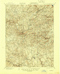
~ Belair MD topo map, 1:62500 scale, 15 X 15 Minute, Historical, 1901, updated 1945
Belair, Maryland, USGS topographic map dated 1901.
Includes geographic coordinates (latitude and longitude). This topographic map is suitable for hiking, camping, and exploring, or framing it as a wall map.
Printed on-demand using high resolution imagery, on heavy weight and acid free paper, or alternatively on a variety of synthetic materials.
Topos available on paper, Waterproof, Poly, or Tyvek. Usually shipping rolled, unless combined with other folded maps in one order.
- Product Number: USGS-5367952
- Free digital map download (high-resolution, GeoPDF): Belair, Maryland (file size: 11 MB)
- Map Size: please refer to the dimensions of the GeoPDF map above
- Weight (paper map): ca. 55 grams
- Map Type: POD USGS Topographic Map
- Map Series: HTMC
- Map Verison: Historical
- Cell ID: 51118
- Scan ID: 257302
- Imprint Year: 1945
- Survey Year: 1900
- Datum: Unstated
- Map Projection: Polyconic
- Map published by United States Geological Survey
- Map Language: English
- Scanner Resolution: 600 dpi
- Map Cell Name: Belair
- Grid size: 15 X 15 Minute
- Date on map: 1901
- Map Scale: 1:62500
- Geographical region: Maryland, United States
Neighboring Maps:
All neighboring USGS topo maps are available for sale online at a variety of scales.
Spatial coverage:
Topo map Belair, Maryland, covers the geographical area associated the following places:
- Deercreek (historical) - Gibson Manor - Amoss - Briar Ridge - Glenwood Garth - Coffman - Chestnut Hill - Leew Woods - McDermott - North Bel Air - Pine Crest - Tollgate Estates - Lindill Estates - Dunsen Heights - Pleasantville - Cloverdale - Haddon Hurst - Chrome Hill Estates - Midsummer Hill - Montford Glen - Harold Heights - Willows - Roland Place - Green Valley - Warwick - Klein - Delano Acres - Rock Spring - Deer Meadows - Harkins - Macton - Hy-Crest - Mount Vernon Estates - Ailston - White House Park - Harford Heritage - Woodside - Chadwick - Locust Knoll - Fountain Glen - Greendale Estates - Creswell - Bel Forest - Frogtown - Tall Oak Manor - Harford Village - Dublin Manor - Viking Highlands - Harvest Hills - Old Fields - Jarrettsville - Furnace - Grose Close - Ferncliff - Huntington - Drexel - Stonehedge - Fountain Green Estates - Hickory Village Mobile Home Park - Fawn Grove - Campus Valley Estates - Voshelle - Cherrywood Estates - Moorland - Advocate Hill Farms - Federal Hill Heights - Baldwin Hills - Grafton Heights - Hickory Hills - Orchard Lakes - Day Meadows - Bramblewood - Joppa Hills - Woodsbrook - Highland View - Scots Fancy - Stoneleigh - Rock Manor - Pylesville - Mechanicsville (historical) - Rutledge - High Point Estates - Harford Estates - Corns Manor - Thomas Run - Gibson - Bel Air - Cedar Spring - Vale Hills - Baldwin Mill Terrace - Meadow Springs - Belle Farm Heritage - Pinehurst - Whispering Woods - Magness - Tudor Manor - Seven Cedars - Wakefield Meadows - Village of Thomas Run - Highfield Park
- Map Area ID: AREA39.7539.5-76.5-76.25
- Northwest corner Lat/Long code: USGSNW39.75-76.5
- Northeast corner Lat/Long code: USGSNE39.75-76.25
- Southwest corner Lat/Long code: USGSSW39.5-76.5
- Southeast corner Lat/Long code: USGSSE39.5-76.25
- Northern map edge Latitude: 39.75
- Southern map edge Latitude: 39.5
- Western map edge Longitude: -76.5
- Eastern map edge Longitude: -76.25


